The pan-European tradition of St. Michael traces
back to
the time of the pagan conversion to Christianity...The association
with pre-Christian relics and monuments suggests that before this
time, the character of 'St. Michael' existed in a different form, and
was connected to events in the solar calendar.
Who Was St. Michael:
It is said in the Bible that
the name Michael (Mi-ka-el), originated when Lucifer (the fallen angel),
compared himself with God, another angel stood before him and shouted
"Who is like God?", which in Hebrew translates as 'Mi-ka-el',
after which he became known as Michael.
In the 'Apocalypse' by the apostle
John, it was written that a dragon with seven crowned heads and
horns, and a tail that swept aside the stars, threatened the virgin Mary
and her newly born child. St. Michael and his angels fought the serpent
from Satan and destroyed it. (2)
Apep, the
Seven-Headed Dragon of Egypt has been identified with Tiamat, the Great
Dragon of Sumeria, slain by Marduk. This primordial goddess is also the
prototype of the biblical monster Leviathan.
In France, it is said that St. Michael fought the devil (Satan,
Lucifer) on
Mont Dol in Brittany - which is part
of an alignment with Mont St. Michel and d'Avranches. In England, tradition places the battle on
Dragon Hill.
St. Michael is said to have appeared to a
13 year old 'Joan of Arc' in 1419. (1)
The spring festival of St. Michael
is on the 8th May.
Mercury, 'The messenger of the Gods', is
sometimes identified with St. Michael. (2)
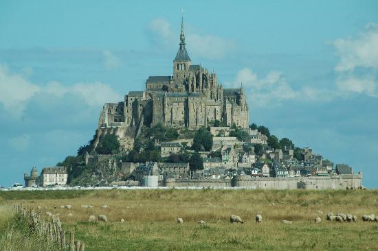
Mont. St. Michel, France:
Mont. St. Michel (Brittany/Normandy Border) -
Mont St. Michel is an island granite outcrop, which was known as Mont
Tombe until the first Monastic settlement in 708 AD, built following
the appearance of St. Michael to the bishop of Avranches.
The
main church at Mont. St. Michel
is orientated at 26� north of true east (The same as at
Notre Dame). This orientation can be extended in
both directions to form an alignment with Mont Dol to the south-west, and Avranches to the north-east.
Mont Dol is the place where
St. Michel is said to have fought Lucifer.
On the 8th of May (the
spring festival of St. Michel), the sun rises over Avranches towards
Mont St. Michel, then Dol-de-Breton.
Mont St. Michel World Heritage
Status Under Threat.
'The French
island abbey of Mont-Saint-Michel is at
risk of losing its World Heritage Status
because of plans to build wind turbines
that could blight the spectacular view.
Campaigners are up in arms, but French
President Nicolas Sarkozy is determined
to turn France into a world leader in
wind power'.
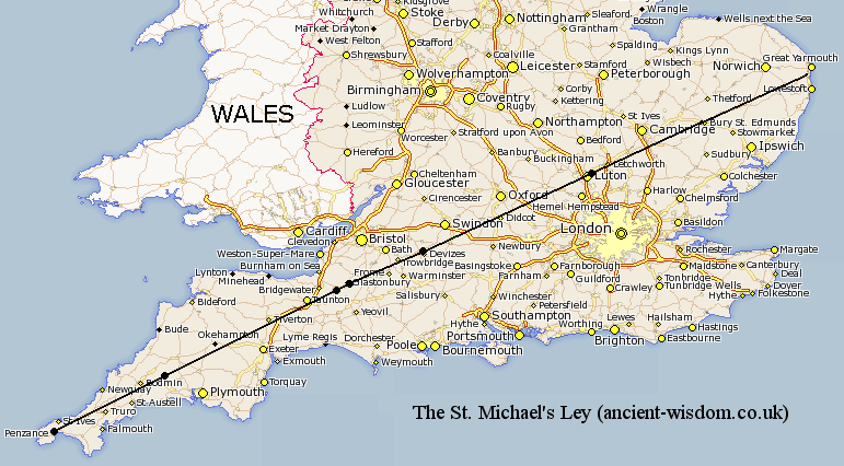
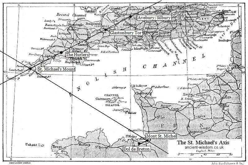
This
is probably the most famous ley-line in the world. It runs
across England from the tip of Cornwall to the Eastern tip of
Norfolk on the Norfolk/Suffolk border, passing through the prehistoric sites of
The Hurlers,
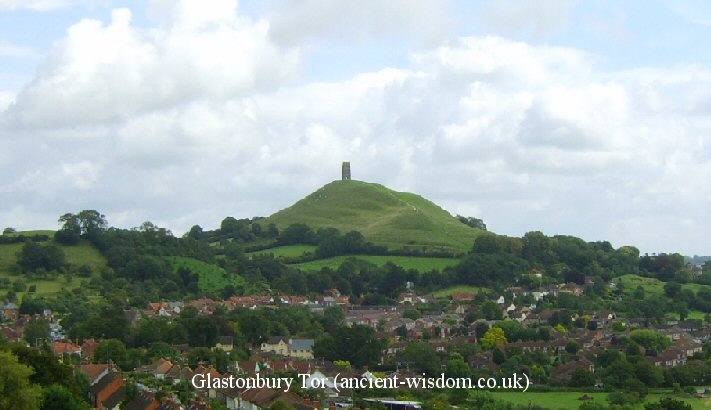
Glastonbury Tor
(St. Michaels church), Avebury, Waulads
Bank and numerous
other significant sites either named after St. Michael or St. George, both dragon
slaying saints.
The line follows the path of the sun on the
8th of May (The spring festival of St.
Michel)
on an azimuth of around 242� (28� north
of east). This day was celebrated in past times as 'Beltane', the beginning
of summer, and a cross-quarter day, marking the midpoint in the Sun's
progress between the spring equinox and summer solstice.
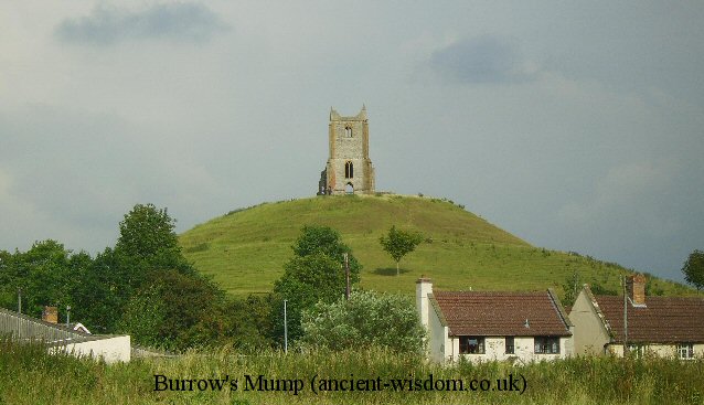
Both Glastonbury Tor and "The Mump" at Burrowbridge some ten miles
to the south-west appear to have been artificially shaped so that their axis
align with each other, with an orientation, 27� north of east. The biggest
divergence from this orientation lies in the first/last section from
The Hurlers Stone circle to St Michael's
Mount, which is much closer to 238� (32� north of east).
It is therefore appropriate that the St. Michael''s ley has been called a
'corridor of incidence' rather than a 'ley-line' as some of the locations along
the alignment are not exactly aligned. Hamish Miller suggested that the
line was actually two lines, one entwining the other, he called the second
line the St. Mary's line due to the number of sites dedicated to her.
The St. Michael's ley-line forms the hypotenuse of a
right angled triangle of enormous proportions which is defined by the
three most sacred sites in England. This line continues North
to Arbor Low, which sits exactly 2
�
North and 1� East of
Glastonbury. (See image, right)
In addition to the more famous prehistoric
landmarks of Glastonbury and Avebury, the St. Michael's ley passes over
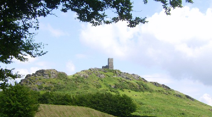
several significant hilltop shrines dedicated to St. Michael. These include the larger
than life conical 'Barrow mump' (Burrow's mump, Burrowbridge mump), ten miles to
the west of Glastonbury, St. Michael's Church at Clifton Hampden, and on
Brent Tor, all of which have ruinous St. Michael's churches on
their summits.
Much of the St. Michael's Ley lies on the far older
Ickneild Street which was defined by Bartholemew's survey Gazetteer of
the British Isles in 1904 as follows:
"Icknield street, ancient Roman road, crossing from E to
SW of England; began in Norfolk and terminated at Land's End."
(4)
This description takes no account of the several important
prehistoric monuments and earth-works, which were already in place along
the alignment thousands of years before the Roman arrival. John Michell
said of it:
'The Whole line ... may in some remote age have formed a
continuous sacred track, for a few isolated stretches still remain. From
Burrowbridge to St. Michael's, Othery ... there was once an old causeway
over the marsh. At Glastonbury in the same alignment the pilgrims path
still runs right along the edge of the tor, and at Avebury the line
exactly coincides for over three miles with what is now the main road to
Devizes from the southern entrance of the stone circle...'
(5)
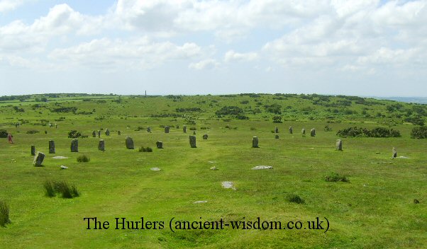
Orion and the St. Michael's Ley, England.
It is noticeable that
the Hurlers triple circle were oriented towards Orion when they were
built, they are also roughly orientated along the axis of the St.
Michaels Ley. Curiously enough, another prehistoric site that sits
on the St Michael's Ley also has a relationship to Orion; The
Dorchester 'Big-rings' are the remains of a Henge (and Cursus) with
similar dimensions as the Stonehenge bank and ditches (366 MY
Circumference). In Yorkshire, the Thornborough Henges were built
with double the circumference to the Big Rings and were orientated
towards Orion.
By watching the
setting of the stars and specifically one star in the belt of Orion
it would have been possible to orientate an alignment from one
hilltop to the next over considerable distances. Beacon fires could
have further reinforced such an alignment. The star in question is
Mintaka which would have reached its extinction point on the
alignment, which has an approximate azimuth of 242� around 2800 BCE.
(7)
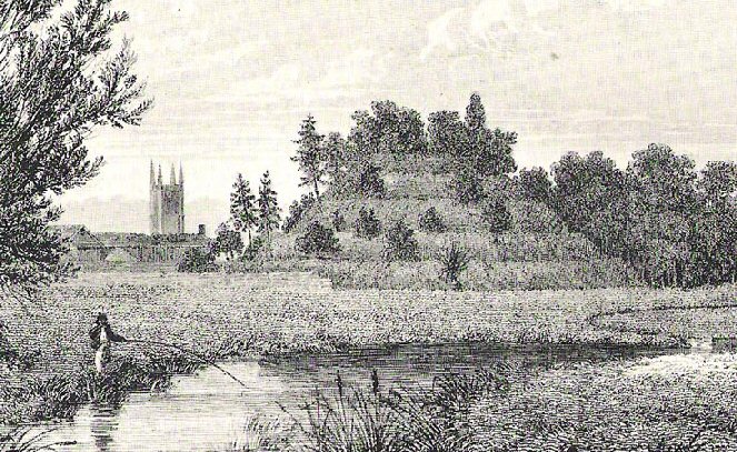
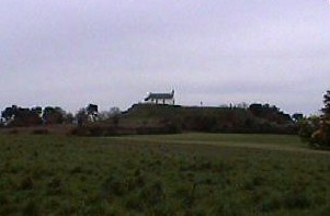
St. Michael's Church, Burrow's
Mump. 12 Miles from Glastonbury (Just visible in the distance)
St. Michael's Church,
Glastonbury Tor.
(Aligned with the St. Michael's Ley).
The pilgrims path leads north-east
away from Glastonbury in the direction of Avebury/Silbury.
Beckhampton Long Barrow
(SU 08704 69107)
A significant Neolithic barrow
dated to 3,000+ B.C. The barrow is aligned
approximately to the orientation of the St. Michael
alignment with a north-eastern entrance pointing to
Avebury. The remains of a 'sacred' pathway (The
Beckhampton Way) leads into Avebury from the
south-west.
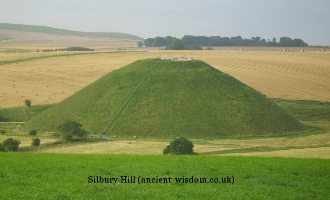
Silbury Hill. The largest man-made
prehistoric structure in Europe.
Avebury (The Largest Stone Circle in the world) is visible from
Silbury Hill.
The two can be viewed as components of a 'ceremonial' landscape
which also include The Sanctuary and
West-Kennet.
The huge mound
that stands in the middle of Marlborough
College was known as 'Merlin�s Mount' and
was said to be his burial mound. New
Carbon dating of pieces of charcoal found
deep within the mound have now dated it to
about 2400 BC. The Marlborough Mound is now
officially the �little sister� of the world
famous Silbury Hill � which dominates the
skyline westwards.
(8)
Dorchester Big Rings (Henge)(SU 57305 95218)
The Big Ring Henge
was part of a cluster of Neolithic sites located in
the area. It had twin circle of ditches with the
outer having a maximum diameter of just under 200
metres. There were two entrances broadly in the
northwest and southeast, Sadly this site has now
completely disappeared under a lake after gravel
extraction in the area.
This large Henge lies
beside several natural springs at the source of the
River Lea, and sits alongside the Iknield Way. It is a
Neolithic D shaped enclosure consisting of a bank and
external ditch of around 7 hectares with a turf reveted
chalk & gravel bank (derived from the ditch material).
The ditch is 9.2 m wide and 2.1m deep.
In the late 1950's Jean Richer
publicized the existence of a main axis of sacred sites in Greece
through Delphi, Athens, Delos, Camiros, Prasaias [Apollo's
Temple], the Temple of
Artemis
at Agra, Eleusis and other sites. The
line links not only Temples and sanctuaries of the god
Apollo
but also sites earlier dedicated to
the goddess
Artemis / Diana.
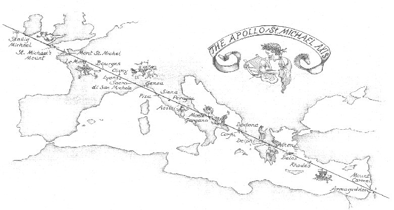
His brother Lucien followed this up in 1977 in an article entitled
'The
Saint Michael
and
Apollo
axis' in which he extended his
brother's line north-west where it passes through the holy island of
Skellig Michael
on the south-western coast of
Ireland, after crossing several of the most important sites in
Europe dedicated to
St. Michael,
the archangel.
There are at least three legends
concerning
Apollo
that seem to refer to this line.
(8)
One legend recalls how Abaris, a
druidic British priest of Apollo,
travelled on the god's golden arrow from the British Isles to Greece
to visit Pythagoras.
( Pythagoras
is also said to have lived for a time
on Mount Carmel in the Holy Land another site on this line).
Another legend describes the return
of Apollo
from the land of The Hyperboreans to
Delphi
in a chariot drawn by swans.
The third concerns what are known as
the 'Hyperborean Gifts.' These, packed in straw, were sent from
Hyperboreans (British?) to Delos as gifts ( tributes) to
Apollo. 'These first fruits, it is said,
are hidden in wheaten straw, and no one knows what they are.' -
Pausanius
This alignment
is said to extend (on a Mercatorial map), from Mont Carmel in Israel through
Delos
(dedicated to Apollo),
Delphi, Corfu (Island of Artemis, sister of
Apollo), Le Monte Gargano in Italy (primary European sanctuary of the
Archangel, and place of several apparitions), La Sacra di San Michele in Piemont (Benedictine monastery at
1000m), Le Mont St. Michel of Normandie,
Saint Mickael's mount, (a peaked
island surmounted by a church off the coast of Cornwall), and Skellig
Michael, an island to the south-east of Ireland. The angle of axis is
orientated SE-NW corresponding to the zodiacal axis of virgo-pisces.
(2)
The
archangel often appeared in Italy, in Rome near the castle which still
bears the name 'Holy angel' and at Monte Gargano, a rocky peninsula on the
Adriatic sea. (2)
The St. Michael Axis: What does it mean
It can be seen from the map
above that the European St.
Michael's ley (Running across Europe from Skellig Michael in Ireland
to Mt. Carmel in Israel), crosses paths with two other St. Michael's
alignments: The St. Michael's ley in England and the Mont St.
Michel alignment in France (see below).
The
larger St. Michael's alignment that crosses Europe from Mont Carmel
in Israel to
Skellig Michael
in Ireland, crosses two other St. Michael's
alignments, both orientated at roughly the same angle (26
�
-28�),
mirroring the larger alignment (along a north/south axis). It has already been
noted that the St.
Michael's ley in England does not follow an exact azimuth across the
country, but meanders on occasion to include naturally high
outcrops, a deviation of one or two degrees is to be expected, and
this is exactly what we find here (perhaps better termed an 'Axis of
Coincidence').
Both the French and the English leylines
have clear
signs of prehistoric activity along its path (such as the Hurlers,
Glastonbury, Avebury, Waulad's Bank, Dol-de-Breton), and also ancient traditions of
celebrating with fires on beacon-hills on may-day (St. Michael's
day), all of which reinforce the idea of a 'functional' and
operative alignment with prehistoric roots. Both alignments also
include numerous churches and pilgrimage points dedicated to St.
Michael (Apollo), that were 'reinforced' throughout the middle-ages
by the church. One suspects that an ancient tradition has been
passed on either knowingly or unsuspectingly during the
Pagan/Christian conversion of Europe.
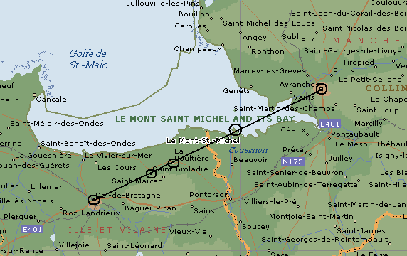
The smaller French alignment
is orientated along the same azimuth as the English St.
Michael's leyline.
The French alignment passes
from
Mont Dol (Where St. Michael is
said to have fought the Devil),
though
Mont St. Michel to Avranches (The Diocese of the Bishop who envisioned St. Michael on Mont St.
Michel). Both the alignment and the monastery he built are oriented on an azimuth of 26� north-east, the same as
the axis of the Champs Elysee (Elysian Fields), in Paris.
Supplementary notes on the European St Michael's
line.:
Skellig Michael, Ireland. - (from
Sceilig Mhich�l in the Irish language, meaning Michael's rock),
After being founded in the 7th century, for 600 years the island was
a centre of monastic life for Irish Christian monks. The monastery
comprises six intact clochans, two oratories, 31 early grave slabs,
a monolithic cross and the 13th century church of St Michael.
Sadly, and Ironically, the newly gained status
from UNESCO is now in danger of being retracted through the over
enthusiastic 'restorations' of the abbey.
The Fabrication of History: Skellig
Michael, Ireland.
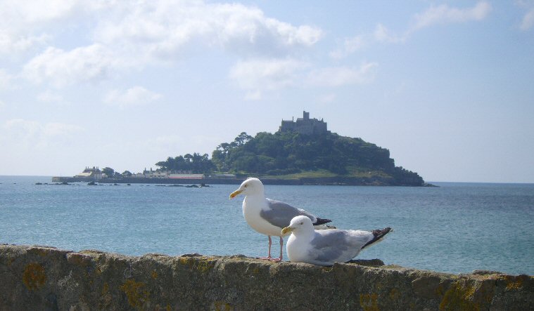
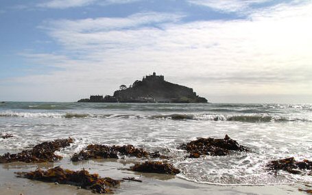
St Michael's Mount, Cornwall, England.
-
(50� 7' 6" N, 5� 28' 39" W) Centre of the English St. Michael's
Axis.
It was here � where an ancient stone chair stands at the entrance to
the castle � that according to legend, a vision of the Archangel St
Michael appeared to some fishermen in the year 495. In 1067,
the monastery of Mont-Saint-Michel gave its support to duke
William of Normandy
in his claim to the throne of England. It was rewarded with
properties and grounds on the English side of the Channel, including
a small island located to the west of
Cornwall, which was modelled after Mont
St. Michel, and became a Norman
priory named St Michael's Mount
of Penzance. (6)
St. Michaels M
ount,
Cornwall was once named Dinsul, meaning Castle or citadel of the
Sun. St. Michael's Mount still retains its Cornish name of 'Karrek
Loos y'n Koos', meaning the 'Grey rock in the Woods' (a remarkable
memory of more than 3,800 years, since the forest surrounding it
has been submerged since at least 1,850 BC).
Legend says that a mythical giant named
Cormoran once lived on the Mount, and he used to wade ashore and
steal cows and sheep from the villagers to feed his gargantuan
appetite. One night, a local boy called Jack rowed out to the
island and dug a deep pit while the giant was asleep. As the sun
rose, Jack blew a horn to wake the angry giant who staggered
down from the summit and � blinded by the sunlight � fell into
the pit and died.
St. Michaels
Mount, Cornwall, England with its strong similarity to Mont St. Michel,
France.
Mont St. Michel, France. -
Centre of the French St. Michael's Axis:
Before the
construction of the first monastic establishment in the 8th
century, the island was called "Monte Tombe". According to
legend,
the Archangel Michael
appeared to St. Aubert,
bishop of Avranches,
in AD708 and instructed him to build a church on the rocky islet. Aubert repeatedly ignored the angel's instruction, until Michael
burned a hole in the bishop's skull with his finger.
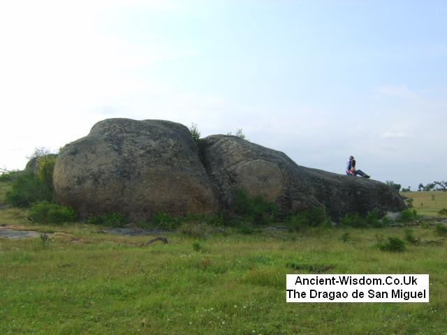
The St. Michael theme is also found
in Portugal. The spectacularly located 'Anta do Tapad�o' as well as
having a superb 360 view, is located right beside a natural rock
formation which has the clear appearance of a Dragon's head (right).
The 'Tumulus of St. michael' is one of the seven great Tumulii of Carnac. (known as Man
�
Lud, Ker Lud,
Er Grah,,
Men� Er Hroeuk, Tumiac, Le Moustier,
and the Tumulus of St. Michel).
In
the centre of the tumuli is a stone box, 6ft wide, by 8ft deep, by 3ft
high. The floor of the box was lined with a stone pavement, upon which
were placed 11 polished axes of Jadeite and 28 polished axes of fibrolite.
Included also were pendants and necklaces of jasper and turquoise, all
covered with ash and scorched human bones. The chamber was completely
sealed with a capstone and surrounded with 15 small 'kist's' containing ox
bones.
This was then built over with a 7m high,
100m long mound, which was orientated east-west. Charcoal from the mound
was Radio-carbon dated to 6,850 BC.
(3)
The mound was later greatly
built over to create the current edifice which stands at over 60m wide and
125m long. Up until the 19th century, the summer solstice was celebrated
in Carnac
by the lighting of a bonfire on its summit. (3)
1). Alain Dag' Naud.
Les Secrets Du Mont Saint-Michel. 1992. Editions Jean-Paul Gisserot.2). Lucien Bely.
Mont St. Michel3). Julian Cope.
The Megalithic European. 2004. Element Books.4). J. Michell; R. Heath.
The lost science of Measuring the Earth. 2006. Adventures Unlimited. (Note: Previously called -
The Measure of Albion).
5).
The New View over Atlantis.
1983. Thames and Hudson.6).
http://www.newadvent.org/cathen/10275b.htm7).
http://www.kch42.dial.pipex.com/michael_alignment.htm8).
http://www.marlboroughnewsonline.co.uk/marlboroughs-mound-is-now-proved-even-older-and-more-mysterious-than-merlin-himself
 Both Glastonbury Tor and "The Mump" at Burrowbridge some ten miles
to the south-west appear to have been artificially shaped so that their axis
align with each other, with an orientation, 27� north of east. The biggest
divergence from this orientation lies in the first/last section from
Both Glastonbury Tor and "The Mump" at Burrowbridge some ten miles
to the south-west appear to have been artificially shaped so that their axis
align with each other, with an orientation, 27� north of east. The biggest
divergence from this orientation lies in the first/last section from
 In
the centre of the tumuli is a stone box, 6ft wide, by 8ft deep, by 3ft
high. The floor of the box was lined with a stone pavement, upon which
were placed 11 polished axes of Jadeite and 28 polished axes of fibrolite.
Included also were pendants and necklaces of jasper and turquoise, all
covered with ash and scorched human bones. The chamber was completely
sealed with a capstone and surrounded with 15 small 'kist's' containing ox
bones.
In
the centre of the tumuli is a stone box, 6ft wide, by 8ft deep, by 3ft
high. The floor of the box was lined with a stone pavement, upon which
were placed 11 polished axes of Jadeite and 28 polished axes of fibrolite.
Included also were pendants and necklaces of jasper and turquoise, all
covered with ash and scorched human bones. The chamber was completely
sealed with a capstone and surrounded with 15 small 'kist's' containing ox
bones.