|
Location:
Wiltshire,
England.
(O/S ST 137326) |
Grid Reference:
51.09 N. 1.80 W. |
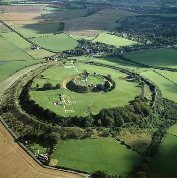
 Old Sarum:
(Neolithic Hill Fort).
Old Sarum:
(Neolithic Hill Fort).
Location of the original Salisbury. Inhabited since
3,000 BC (1).
This spectacular
hill-fort was once one of the most important places in England. It's
importance is highlighted by the fact that it was variously occupied
by the Romans, Saxons and Normans.
Old Sarum lies on
one of the earliest recognised examples of leylines as determined by
Sir N. Lockyer. It is connected to both Salisbury and Stonehenge,
both sacred places on the Wiltshire landscape.
Although not
much is known of the earliest years of this important structure,
archaeological remains of rough stone tools suggest people have
occupied the hilltop area of Old Sarum since
Neolithic times (around 3000 BC).
(1) The banks of the structure
were begun almost 5000 years ago, and remained intact until the
Roman invasion. At this time it was called Sorviodunum.
Following the
departure of the Romans, the Saxons are known to have used the site,
arriving in 552 BC, they called the site Searobyrg but when the
Normans came they realised its strategic importance and
constructed a motte and bailey castle within the old earthworks.
After the
Norman conquest of England in 1066, William the Conqueror used
Old Sarum as a base of operations. William moved the bishopric
from the Anglo-Saxon Sherborne Cathedral to Old Sarum,
appointing his nephew, Osmund de Sees, as his chancellor and
Bishop of Salisbury. Osmund had the first cathedral at Old Sarum
built, completed in 1092
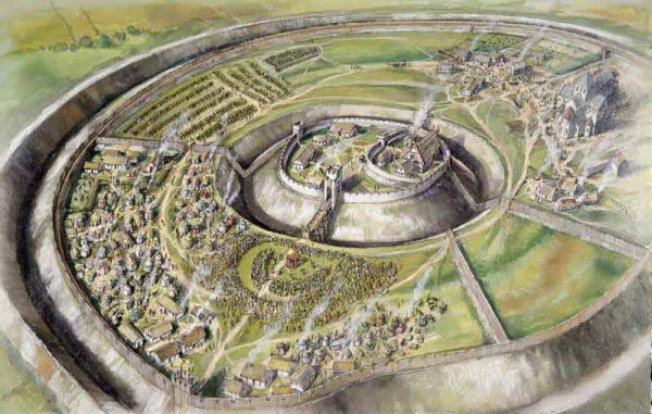
The earlier
castle was replaced by a stone keep in 1100, and a royal palace
was erected within the banks in 1130. In the meantime the first
cathedral on the site was completed in 1092, but it burned down
only 5 days after it was consecrated. A new, larger cathedral
was completed around 1190.
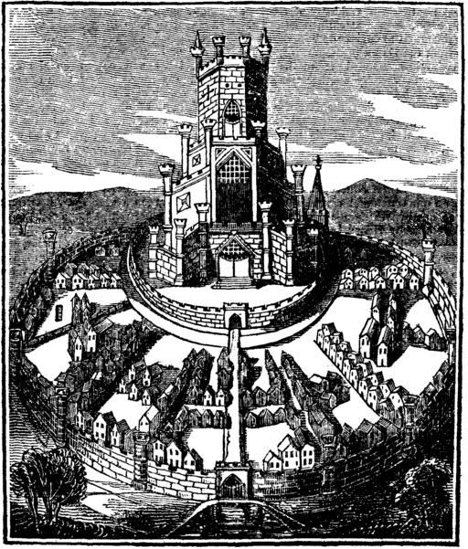
Early
Wood-cut of Old Sarum.
A contemporary observer, Peter of Blois (c.1135 � 1203) described
Old Sarum as �barren, dry, and solitary, exposed to the rage of the
wind; and the church (stands) as a captive on the hill where it was
built, like the ark of God shut up in the profane house of Baal.�
In 1219 Bishop
Richard Poore decided to build a new cathedral at a location
several miles to the south. Stone from the old cathedral was
used to build the new one. A settlement grew up around the site
of the new cathedral, and it is this settlement that is the
modern city of Salisbury. With the shift of settlement away from
Old Sarum to New Sarum (Salisbury) the old site lapsed and the
castle fell into disuse. Despite the fact that the site was
derelict, Old Sarum continued to send a representative to
Parliament until the mid 19th century.
According to legend, the bishop d'Avranches decreed that an arrow
would be fired from the walls of the keep, and the new cathedral
would be built wherever it fell. Miraculously, however, the arrow
struck a passing deer, who fled a full two miles to the banks of the
Avon
The Old Sarum Leyline.
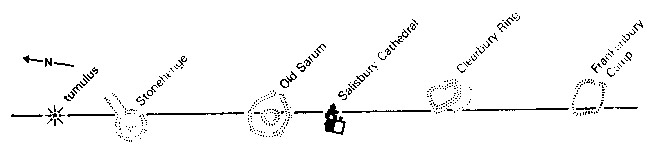
It is a curious
coincidence, in relation to the myth of the creation of new
Salisbury to find that Old Sarum and New Sarum (Salisbury) both lie
in an alignment with Stonehenge. It is significant in that it lies
on the same azimuth as the Glastonbury Ley, and is approximately the
same length.
(See
both on the Leyline map of England)
This is
another classic alignment originating with Sir Norman Lockyer.
It runs for 181/2 miles NNW-SSE passing through Stonehenge.
The line
starts N of Stonehenge at a tumulus (12004409) on Durrington
Down, proceeds towards Stonehenge, which is just visible from
the barrow, and crosses the Cursus on its way. It misses the
sarsen circle at Stonehenge, but crosses ley SW7 on the edge of
the earthwork just where the Avenue connects to it.
The ley
continues SSE to Old Sarum (13823272) an impressive earthwork
enclosure with extremely deep ditches. This is yet another
example of an evolved site, having been an Iron Age hill-fort,
then a Roman town which in turn was superseded by pagan Saxon
occupation until finally, in medieval times, a hill town with a
keep and a cathedral occupied the site. Legend has it that
Bishop Poore had a vision of the Blesses Virgin, who told him to
build at a certain place. He didn't know where this was to be
until informed by local people.
So Salisbury
Cathedral (14312954) came to be founded on its present site. The
ley passes marginally to the E of the outstanding 404 foot spire
which, according to the late Guy Underwood, marks an
exceptionally powerful blind spring. The spire also seems to
attract the mysterious White Birds of Salisbury Plain - large
albatross-like birds, dazzlingly white, which are said to appear
whenever a bishop of Salisbury is dying. They were certainly
seen in 1911, accurately foretelling the death of the then
bishop.
When the
cathedral was transferred from Old Sarum, the body of St. Osmund
was brought down and placed in a shrine within the new building.
There is also a tomb in the cathedral containing the body of the
murderer Lord Stourton, who was hanged with a silken noose. For
a long time a wire noose hung over the tomb but was removed in
1780. However, its luminous outline could still be seen, even
'within living memory by unimpeachable witnesses'.
Crossing
Salisbury, the line goes through a crossroads near Odstock and
on to Clearbury Ring (15132443), where it passes through the NW
corner of the earthworks. This Iron Age camp is wooded and can
be seen for great distances as a clump, but the earthworks
themselves are not particularly impressive visually.
Michell has
observed that the line from Stonehenge to Clearbury is 19,800
(660x30) yards in length, exactly 30 times the length of twin
geomantic circles he discovered over Glastonbury. The fact that
this ley is virtually at the same angle as the Glastonbury ley
reinforces this correspondence.
(More about Ley-lines)
Old Sarum: Gallery of
Images.
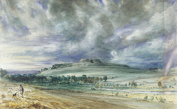
Old Sarum By John Constable. (1776-1837). Victoria
and Albert Museum, London.
(TheSalisbury
Complex)
(More
about English Geodesy)
(Other
Prehistoric English Sites)
|