|
 Cartography:
(Prehistoric Mapping)
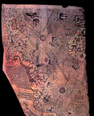
Cartography is a skill that requires several disciplines to achieve
accuracy. Skills such as mathematics, geometry, navigation and organisation,
are minimum requirements for the cartographic enterprises that appear to
have been executed in the past.
Featured Items:
|
Cartography in Prehistory: |
The unofficial oldest map in the world was discovered in Ukraine in 1966,
dating
from about 11 - 12,000 B.C. Inscribed on a mammoth tusk it was found in Mezhirich, Ukraine. It has been interpreted to show a river with
dwellings along a river. However, the best claim to the title of "the
earliest map in the world" appears on a beautifully engraved silver vase
from Maikop in Ukraine, according to James and Thorpe. It was
found in a Ukrainian tomb dated at 5,000 years old. It shows two
rivers, a mountain range, a lake or sea and wild animals
(3).
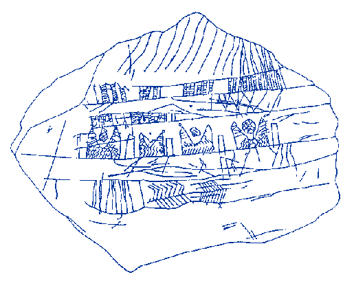
The oldest map in the world.. Inscribed on mammoth
tusk, Ukraine.
What may be one of the oldest
authenticated maps in the world, is dated to approximately 6000 BC, and was
unearthed in an archaeological excavation at
Catal Huyuk in west-central
Turkey in 1963. Its subject matter was the Neolithic town it was found in.
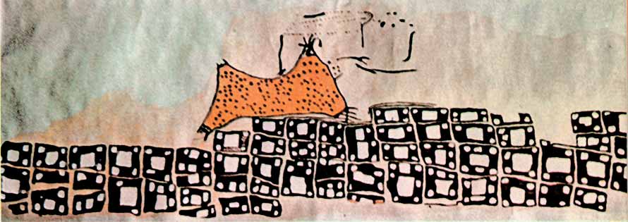
Painted on a wall, it showed the streets and houses in plan form, lying
beneath the profile of the mountain of Hazan Dag with its volcano
erupting.
The Valcamonica Valley already has over 300,000
recognised petroglyphs running from the Palaeolithic period to the
Middle-ages. Amongst the inscriptions are several images of
'topographical compositions', or 'maps'. They are dated from
Neolithic to early bronze-age.
(4)
Typified by figures with maps (rectangular
or round geometric topographic figures), spirals and probably no more at
Luine, Paspardo, Vite, Dos Sottolajolo.
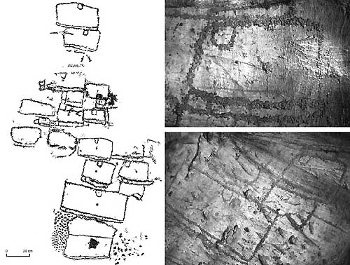 Topographic
compositions, or maps, are constituted by regularly repeated geometric
modules. Topographic
compositions, or maps, are constituted by regularly repeated geometric
modules.
They are the only figures which are covered by the Copper
Age figures (Borno 1, Bagnolo 1, Ossimo 8). Basing on the study of the
superimpositions, the maps represent the most ancient phase (apart the
Epi-palaeolithic style) of the Valcamonica rock art (a similar
consideration should be reflected in the Mt. Bego rock art). Some
compositions which have been interpreted by Anati as idols (Sellero,
Paspardo) and assigned to the Style II, are more likely to be
interpreted as maps. (4)
Topographic composition at Vite,
Paspardo, late Neolithic - first Copper Age (photo A. Arc�)
(More
about Val Camonica, Italy)
List of Prehistoric Maps.
|
Prehistoric maps |
Museum |
Country |
|
Pavlov map (24000-25000 BC) |
Archaeological museum, Dolni Vestonice |
Czech republic |
|
Mezherich map (11000-12000 BC) |
Museum of natural history, Kiev |
Ukraine |
|
Maikop map (2000-3000 BC) |
Eremitage, St. Petersburg |
Russia |
| Catal Huyuk
(6,000 BC) |
Museum of
Anatolia Civilisations, Ankara. |
Turkey |
|
Gold plate of Moordorf (1500 BC) |
Niedersachsisches Landesmuseum, Hannover |
Germany |
|
Nebra map (1400 BC) |
Landesmuseum fur Vorgeschichte, Halle/Saale |
Germany |
|
Petroglyphs (1000-1500 BC) |
Archeological monument �Stone Grave�, Melitopol. |
Ukraine |
|
Nippur map (1500 BC) |
Hilprecht-Collection of middle-east antiquities,
Jena university. |
Germany |
|
World map of Babylon (500 BC) |
British Museum, London |
Great Britain. |
Although the first 'maps' were more conceptual than
geometric, the skills required for accurate cartography can be seem in the
earliest maps..
|
The
Babylonian "map of the world" (BM 92687).
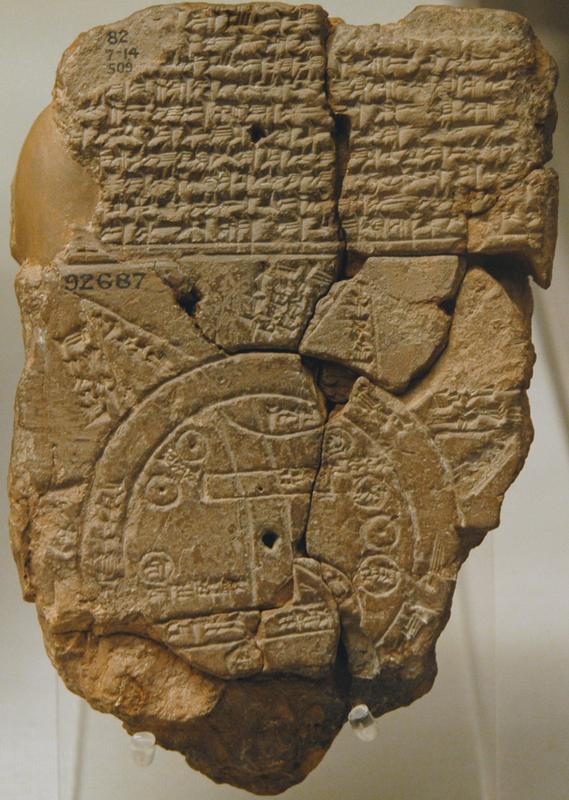 Babylonian "map of the world" in
the British Museum, London was long claimed as the earliest extant
map. The map was composed in Babylonia and is the only Babylonian
map drawn on an international scale. It is a Neo-Babylonian (Persian
Period, circa 500 BCE) copy of an original dating to the Sargonid
Period, circa late eighth or seventh century BCE. The clay tablet is
a drawing and textual description of the Babylonian cosmos. It is
oriented to the north-west. (It is uncertain whether the
accompanying cuneiform text was composed together with the map.) It
is the only known map of the world dating from the Neo-Babylonian
Period. All other maps have a purely local focus. Babylonian "map of the world" in
the British Museum, London was long claimed as the earliest extant
map. The map was composed in Babylonia and is the only Babylonian
map drawn on an international scale. It is a Neo-Babylonian (Persian
Period, circa 500 BCE) copy of an original dating to the Sargonid
Period, circa late eighth or seventh century BCE. The clay tablet is
a drawing and textual description of the Babylonian cosmos. It is
oriented to the north-west. (It is uncertain whether the
accompanying cuneiform text was composed together with the map.) It
is the only known map of the world dating from the Neo-Babylonian
Period. All other maps have a purely local focus.
It depicts a "bird's-eye" view of
the world and shows a flat, round world with the city of Babylon in
the centre. (Circa 500 BCE Babylon was still a flourishing city and
regarded as the centre (i.e., the "hub") of the world. In the third
millennium BCE Nippur was considered to be the city at the centre of
the world.) It is likely that the Sumerians made the city of Nippur
the centre of the universe (a Sumerian Rome) from about 2300 BCE
(just prior to the Ur III Period). Political supremacy was regarded
as conditional on the possession of Nippur. With the rise to
political supremacy of the Babylonian kings, from the early
2nd-millennium onwards, it was possible for Babylon to claim the
central position and replace Nippur as the centre of the universe.
The map depicts the world as two
concentric circles, with triangular areas radiating from the outer
circle. The area within the inner circle represents the central
continent where Babylon and Assyria are located. The area between
the two circles is the earthly (cosmic?) ocean. The area beyond the
outer circle consists of the triangular areas, which are the
uncharted regions. The continent on the map contains various
geometric shapes representing places and topographic features. The
place names include the countries of Assyria (indicated north-east
of Babylon), Urartu (Armenia) (indicated north of Assyria), the land
of Habban (South Yemen) (indicated south-west of Babylon) and the
city of Babylon. The topographic features include a mountain, a
swamp, and a channel. (The mountains are located at the top, in the
north.) Babylon is represented by a large rectangle encompassing
almost half the width of the central continent. Assyria is
represented as a small oval. (Various nameless places are also
indicated by ovals.) The Euphrates River, which originates in the
mountains at the top of the map, runs through Babylon and flows into
the marshes at the bottom of the map. The continent is surrounded by
the circle of salty ocean. The map schematically portrays the entire
kingdom of Babylonia. The text contains the names of countries and
cities but, on the reverse side, the text is largely concerned with
a description of the seven unnamed outer regions ("islands") which
are depicted in the form of equal triangles rising beyond the
encircling earthly (cosmic?) ocean.
The text (on both sides of the
tablet) shows that the map attempts to depict the entire world. The
emphasis on distant places in the text accompanying the map
indicates that the likely purpose of the map was to locate and
describe distant regions. The text of the reverse of the tablet
describe the "seven islands" in detail. (From the paucity of the
information given it is evident that the Babylonians knew little
about these "islands." Mostly, the description given is mostly about
their various degrees of brightness.) From the text on the reverse
of the tablet, and the inscriptions on the map itself, it can be
determined that the first "island" lay in the south-east. the second
"island" lay in the south-west, and so on, so that the sequence of
the "islands" is somewhat analogous with the hands of a modern
clock. The descriptions of the first and second outer regions are
not preserved.
Other textual sources describe he
earthly ocean as being enclosed by a double range of mountains,
those to the east and those to the west (the "sunrise" and "sunset"
range, respectively.
The map has a definite orientation
- it is inclined. The orientation is such that that the northwest is
at the top. Thus the Babylonian system of orientation did not follow
the perpendicular plane - north, west, south, and east - of our
Western cardinal points. The Babylonian system of orientation was
based upon the prevalent winds. The northwest wind was sent from the
goddess Ishtar and was a favourable wind.
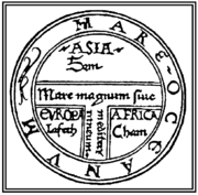
Note the similarity between
the Babylon map and St. Isildoe's Map of the world. (above) 1475.
For further discussion of the
Babylonian world map see:
Eckhard Unger.
Cosmos Picture to the World Map.
(Volume 2, Pages 1-7) 1937. Imago
Mundi.
I.L. Finkel, 'A join to the Map
of the World: a notable discovery', British Museum Magazine:
the Journal of the British Museum Friends (Winter 1995), pp.
26-27
|
 The
Piri-Reis map: This is potentially one
of the most significant finds of
modern time. The Piri-reis map (c. 1513), shows the coastlines of the
American and Antarctic continents. It also includes the outline of the
Antarctic continent which has been frozen over since around 4,000 BC. This
map alters all previous conceptions of our pre-historic ancestors abilities. One of several 'portellano's', which appear to have a
geometric basis of unknown provenance. This map has many
interesting features, such as:- The
Piri-Reis map: This is potentially one
of the most significant finds of
modern time. The Piri-reis map (c. 1513), shows the coastlines of the
American and Antarctic continents. It also includes the outline of the
Antarctic continent which has been frozen over since around 4,000 BC. This
map alters all previous conceptions of our pre-historic ancestors abilities. One of several 'portellano's', which appear to have a
geometric basis of unknown provenance. This map has many
interesting features, such as:-
The map has
pre-Columbian provenance.
The map shows the coastline of America.
The map shows accurate use of
Longitude and Latitude.
The map-builders used 'Spherical geometry'.
The map centres at
the junction of the 23.5˚
parallel (Tropic of cancer), and the longitude of Alexandria.
(More
about the Piri-reis map)
Siberian article: THE MAP OF "THE CREATOR"
A find of
Bashkir scientists is contrary to traditional notions of human history:
Stone slabs covered with the relief map of Ural
Region.
 This
seems to be impossible. Scientists of Bashkir State University have found
indisputable proofs of an ancient highly developed civilization's existence.
The question is about a great plate found in 1999, with a picture of the
region done according to an unknown technology. This is a real relief map.
Today's military has almost similar maps. The map contains civil engineering
works: a system of channels with a length of about 12,000 km, weirs,
powerful dams. Not far from the channels, diamond-shaped grounds are shown,
whose destination is unknown. The map also contains numerous inscriptions.
At first, the scientists thought that was Old Chinese language. Though, it
turned out that the inscriptions were done in a hieroglyphic-syllabic
language of unknown origin. The scientists never managed to read it This
seems to be impossible. Scientists of Bashkir State University have found
indisputable proofs of an ancient highly developed civilization's existence.
The question is about a great plate found in 1999, with a picture of the
region done according to an unknown technology. This is a real relief map.
Today's military has almost similar maps. The map contains civil engineering
works: a system of channels with a length of about 12,000 km, weirs,
powerful dams. Not far from the channels, diamond-shaped grounds are shown,
whose destination is unknown. The map also contains numerous inscriptions.
At first, the scientists thought that was Old Chinese language. Though, it
turned out that the inscriptions were done in a hieroglyphic-syllabic
language of unknown origin. The scientists never managed to read it
"The more I learn the more I understand that I know nothing," - the doctor
of physical and mathematical science, professor of Bashkir State University,
Alexandr Chuvyrov admits. Namely Chuvyrov made that sensational find.
Already in 1995, the professor and his post-graduate student from China Huan
Hun decided to study the hypothesis of possible migration of Old Chinese
population to the territory of Siberia and Ural. In an expedition to
Bashkiria, they found several rock carvings done in Old Chinese language.
These finds confirmed the hypothesis of Chinese migrants. The subscriptions
were read. They mostly contained information about trade bargains, marriage
and death registration.
Though, during the searches, notes dated the 18th century were found in
archives of Ufa governor-general. They reported about 200 unusual stone
slabs which were situated not far from the Chandar village, Nurimanov
Region. Chuvyrov and his colleague at once decided that slabs could be
connected with Chinese migrants. Archive notes also reported that in
17th-18th centuries, expeditions of Russian scientists who investigated Ural
Region had studied 200 white slabs with signs and patterns, while in early
20th century, archaeologist A.Schmidt also had seen some white slabs in
Bashkiria. This made the scientist start the search. In 1998, after having
formed a team of his students, Chuvyrov launched the work. He hired a
helicopter, and the first expedition was flying around of the places where
the slabs were supposed to be. Though, despite all efforts, the ancient
slabs were not found. Chuvyrov was very upset and even thought the slabs
were just a beautiful legend.
The luck was unexpected. During one of Chuvyrov's trips to the village,
ex-chairman of the local agricultural council, Vladimir Krainov, came to him
(apropos, in the house of Krainov's father, archaelogist Schmidt once
stayed) and said: "Are you searching for some stone slabs? I have a strange
slab in my yard." "At first, I did not took that report seriously, -
Chuvyrov told. - Though, I decided to go to that yard to see it. I remember
this day exactly: July 21, 1999. Under the porch of the house, the slab with
some dents lied. The slab was so heavy that we together could not take it
out. So I went to the city of Ufa, to ask for help."
In a week, work was launched in Chandar. After having dug out the slab, the
searches were stroke with its size: it was 148 cm high, 106 cm wide and 16
cm thick. It weighed at least one ton. The master of the house made special
wooden rollers, so the slab was rolled out from the hole. The find was
called "Dashka's stone" (in honour of Alexandr Chuvyrov's granddaughter born
the day before it) and transported to the university for investigation.
After the slab was cleaned of earth, the scientists could not believe their
eyes... "At first sight, - Chuvyrov says, - I understood that was not a
simple stone piece, but a real map, and not a simple map, but a
three-dimensional. You can see it yourself."
"How did we manage to identify the place? At first, we could not imagine the
map was so ancient. Happily, relief of today's Bashkiria has not changed so
much within millions of years. We could identify Ufa Height, while Ufa
Canyon is the main point of our proofs, because we carried out geological
studies and found its track where it must be according to the ancient map.
Displacement of the canyon happened because of tectonic slabs which moved
from East. The group of Russian and Chinese specialists in the field of
cartography, physics, mathematics, geology, chemistry, and Old Chinese
language managed to precisely find out that the slab contains the map of
Ural region, with rivers Belya, Ufimka, Sutolka," - Alexandr Chuvyrov said
while showing the lines on the stone to the journalists. - You can see Ufa
Canyon - the break of the earth's crust, stretched out from the city of Ufa
to the city of Sterlitimak. At the moment, Urshak River runs over the former
canyon." The map is done on a scale 1 : 1.1 km. Alexandr Chuvyrov,
being a physicist, has gotten into the habit of trusting the results of this
investigation.
 The Geological structure of the slab was determined: it consists of three
levels. The base is 14 cm chick, made of the firmest dolomite. The second
level is probably the most interesting, "made" of diopside glass. The
technology of its treatment is not known to modern science. Actually, the
picture is marked on this level. While the third level is 2 mm thick and
made of calcium porcelain protecting the map from external impact. The Geological structure of the slab was determined: it consists of three
levels. The base is 14 cm chick, made of the firmest dolomite. The second
level is probably the most interesting, "made" of diopside glass. The
technology of its treatment is not known to modern science. Actually, the
picture is marked on this level. While the third level is 2 mm thick and
made of calcium porcelain protecting the map from external impact.
"It should be noticed, - the professor said, - that the relief has not been
manually made by an ancient stonecutter. It is simply impossible. It is
obvious that the stone was machined." X-ray photographs confirmed that the
slab was of artificial origin and has been made with precision tools.
At first, the scientists supposed that the ancient map could have been made
by the ancient Chinese, because of vertical inscriptions on the map. As well
known, vertical literature was used in Old Chinese language before 3rd
century. To check his supposition, professor Chuvyrov visited Chinese empire
library. Within the 40 minutes he could spend in the library according to
the government's permission; he looked through several rare books, though
not one of them contained literature similar to that one on the slab. After
the meeting with his colleagues from Hunan university, he completely gave up
the version about "Chinese track." The scientist concluded that porcelain
covering the slab had never been used in China. Although all the efforts to
decipher the inscriptions were fruitless, it was found that the literature
had hieroglyphic-syllabic character. Chuvyrov, however, states he has
deciphered one sign on the map: it signifies latitude of today's city of Ufa.
The longer the slab was studied, the more mysteries appeared. On the map, a
giant irrigation system could be seen: in addition to the rivers, there are
two 500-metre-wide channel systems, 12 dams, 300-500 metres wide,
approximately 10 km long and 3 km deep each. The dams most likely helped in
turning water in either side. To create them over 1 quadrillion cubic metres
of earth was moved. In comparison with that irrigation system, Volga-Don
Channel looks like a scratch on the today's relief. As a physicist, Alexandr
Chuvyrov supposes that now mankind can build only a small part of what is
pictured on the map. According to the map, initially, Belaya River had an
artificial river-bed.
It was even difficult to determine an approximate age of the slab. At first,
radio-carbon analysis was carried out, afterwards levels of the slab were
scanned with uranium chronometer, though the investigations showed different
results and the age of the slab remained unclear. While examining the stone,
two shells were found on its surface. The age of one of them -
Navicopsina munitus of Gyrodeidae family - is about 500 million years,
while of the second one - Ecculiomphalus princeps of
Ecculiomphalinae subfamily - is about 120 million years. Namely that age
was accepted as a "working version." "The map was probably created at the
time when the Earth's magnetic pole situated in the today's area of Franz
Josef Land, while this was approximately 120 million years ago, - professor
Chuvyrov says. - The map we have is beyond of traditional perception of
mankind and we need a long time to get used to it. We have gotten used to
our miracle. At first we thought that the stone was about 3,000 years. That
mis-calculated age was gradually growing. Then we identified the shells
ingrained in the stone to identify some objects. But, who could say that the
shell was alive while being ingrained in the map? The map's creator probably
used a petrified find."
What could be the destination of the map? That is probably the most
interesting thing. Materials of the Bashkir find were already investigated
in Centre of Historical Cartography in Visconsin, USA. The Americans were
amazed. According to them, such three-dimensional map could have only one
destination - a navigational one, and it could be worked out only through
aerospace survey. Moreover, namely now in the US, work is being carried out
in the creation of a world three-dimensional map like that. The Americans
intend to complete the work by 2010. The question is that while compiling
such three-dimensional map, it is necessary to work over very many figures.
"Try to map at least a mountain! - Chuvyrov says. - The technology of
compiling such maps demands super-power computers and aerospace survey from
the Shuttle." So, who then did create this map? Chuvyrov, while speaking
about the unknown cartographers, is wary: "I do not like talks about some
UFO and extraterrestrial. Let us call the author of the map simply - the
creator."
 It
looks like that who lived and built at that time used only air transport
means: there are no marked roadways on the map. Perhaps they used water
ways. There is also an opinion, that the authors of the ancient map did not
live there at all, but only prepared that place for settlement through
draining the land. This seems to be the most probable version, though
nothing could be stated (as fact) for the time being. Why not assume that
the authors belonged to a civilization which existed earlier? It
looks like that who lived and built at that time used only air transport
means: there are no marked roadways on the map. Perhaps they used water
ways. There is also an opinion, that the authors of the ancient map did not
live there at all, but only prepared that place for settlement through
draining the land. This seems to be the most probable version, though
nothing could be stated (as fact) for the time being. Why not assume that
the authors belonged to a civilization which existed earlier?
Latest investigations of the map brings one sensation after another. Now,
the scientists are sure of the map being only a fragment of a big map of the
Earth. According to some hypothesis, there were totally 348 fragments like
that. The other fragments could be probably somewhere near there. In
outskirts of Chandar, the scientists took over 400 samples of soil and found
out that the whole map had been most likely situated in the gorge of
Sokolinaya Mountain (Falcon Mountain). Though, during the glacial epoch it
was tore to pieces. But if the scientists manage to gather the "mosaic," the
map should have an approximate size of 340 x 340 m. After having studied the
archive materials, Chuvyrov ascertained the approximate place where four
pieces could be situated: one could lie under one house in Chandar, the
other - under the house of merchant Khasanov, the third - under one of the
village baths, the fourth - under the bridge's pier of the local
narrow-gauge railway.
In the meantime, Bashkir scientists send out information about their find to
different scientific centres of the world; in several international
congresses, they have already given reports on the subject: The Civil
Engineering Works Map of an Unknown Civilization of South Ural."
The find of Bashkir scientists has no analogues. With only one exclusion.
When the research was at its height, a small stone - chalcedony - got to
professor Chuvyrov's table, containing a similar relief. Probably somebody,
who saw the slab wanted to copy the relief. Though, who and why?
Translated by Vera Solovieva (Source: Pravda - Russia)
|


 Topographic
compositions, or maps, are constituted by regularly repeated geometric
modules.


 The Geological structure of the slab was determined: it consists of three
levels. The base is 14 cm chick, made of the firmest dolomite. The second
level is probably the most interesting, "made" of diopside glass. The
technology of its treatment is not known to modern science. Actually, the
picture is marked on this level. While the third level is 2 mm thick and
made of calcium porcelain protecting the map from external impact.