|
Location:
Chelyabinsk,
Russia. |
Grid Reference:
52.63� N, 59.56� E. |
 Arkaim:
(Prehistoric CitadelCulture).
Arkaim:
(Prehistoric CitadelCulture).
 Twenty of the
spiral-shaped settlements,
believed to be the original home
of the Aryan people, have been
identified, and there are about
50 more suspected sites. They
all lie buried in a region more
than 640km long near Russia's
border with Kazakhstan. Twenty of the
spiral-shaped settlements,
believed to be the original home
of the Aryan people, have been
identified, and there are about
50 more suspected sites. They
all lie buried in a region more
than 640km long near Russia's
border with Kazakhstan.
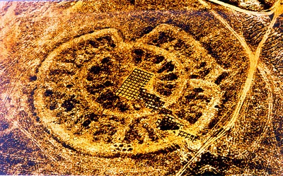
The
ancient Ural fortress Arkaim located in the Chelyabinsk region is
often called the �Russian Stonehenge.� In addition to streets and buildings
scientists have found remnants of a water system, metallurgic
furnaces, and mines. It is also said to be one of the strongest
'anomaly zones' in Russia.
The remains have been dated to c.
2000-1600 B.C. (Gening, Zdanovich 1993, Zdanovich 1995, 1997)
(4)
(Map
with Location)
The
first official sighting of
Arkaim was in 1935... 'Using
information derived from
military aerial photography, the
geologist, Batenina, identified
a number of these fortresses
during the 1960s. A complex of
17 fortresses was discovered in
the southern Urals in the region
of Magnitogorsk, Troizk, and
Orenburg. Excavations have been
undertaken at the settlements of
Sintashta, Arkaim, Ustje,
Kujsak, and others'. (Genning
et al 1992: fig. 1; Zdanovich
1995; Vinogradov 1995; Malutina
et al 1995). The first research
on the Prehistory of Arkaim came
in the same year: Batenina, T.
M. 1935. Distentsionnye
metody pri-ercheologicheskich
issledovaniyan v sapovednike
Arkaim, pp. 105�6 in
Kultura drevnih narodov
stepnoi Evrasii i fenomen
protogorodskoi civilizacii
yuzshnogo Urala 1.
Chelyabinsk (�Distant methods of
archaeological investigations in
the Arkaim.� Culture of the
ancient peoples of the Eurasian
steppe and the phenomenon of
proto-city civilization).
(5)
In 1987, Arkaim valley in
the Southern Urals was going
to be flooded and turned
into an artificial lake. But
before that would happened
archaeologists were given a
year to find out about the
mysterious circles. When
archaeologists begun to work
they found out that those
circles were Arkaim's
settlements! It was a
sensation! Arkaim is
not only a settlement, but
it is also a temple and an
astronomic observatory! It
was round and was 160 meters
in diameter. It was
surrounded by a ditch that
was filled with water. An
outside wall was very
massive, the height was 5.5
meters and width was 5
meters. The wall had four
gates. The largest gate was
south-west gate. All the
buildings were shaped in
half rounds and were
connected to the outside
wall. Each building had exit
to the main street in the
city.
Arkaim was built with four
entrances to the city
strictly oriented at
cardinal points. It was
built according to a
previously designed plan,
with a high level of
precision. All
circumferences have one
centre where all radial
feeders meet together.
(3)
The residential area of the
fortress boasted advanced
amenities considering the time
it was built in. The pavement
made of thick logs hid a sewage
system. Two round one-storey
houses positioned along the
perimeter between the two
fortified walls comprised
separate apartments, a hundred
or more square meters each. In
addition to several rooms, each
apartment had a hearth and a
well. In the very centre of the
city-fortress was a square where
religious rites were performed.
The first city, known as
Arkaim, was rediscovered in
1989, soon after the soviet
authorities allowed
non-military aerial
photography for the first
time. The full extent of the
remains is only now becoming
apparent. Items that have so
far been dug up include many
pieces of pottery covered in
swastikas, which were widely
used ancient symbols of the
sun and eternal life.
(3)
The shape of each of the
cities, which are mainly in
the Chelyabinsk district,
are circular, divided into
segments with a uniform
street plan. The
settlements, which would
each have housed about 2000
people are all surrounded by
a ditch and have a square in
the middle.
(3)
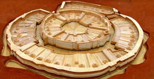
Reconstruction of
Arkaim Citadel
The city was
destroyed completely by fire. Among the archaeological finds
there are no human remains or bones of domestic animals. No
valuables, no jewellery, no religious objects.
Tradition and Folklore in the
Arkaim Region:
Arkaim is interesting not only
as a historic monument. It is
reported to be one of the
strongest 'anomaly' zones in
Russia.
Locals believe it to be a sacred
place. Pilgrims come here all
year round to get some healing
water from the Bolshaya
Karaganka River, and in the
summer they coat themselves with
clay. They say it helps treating
skin diseases.
The mountains surrounding the
fortress are also unusual. The
most famous one is Shamanka (or
Bold Mountain). People climb to
its top to get some positive
energy, pray or meditate. People
in serious medical condition are
brought there for healing.
Visitors come to the top of
Repentance Mountain to ask for
forgiveness. Love Mountain is
believed to bring personal luck.
The nearby Male Forest is
visited by women who have
relationship problems. The
rumour has it, a walk in this
forest will make a woman popular
with men. The growth near
Grachinaya Mountain (also called
Blessed) is infamous. Birch
trunks there are abnormally
crooked at the bottom. They say
people cannot stay there for too
long, otherwise they risk losing
their mind.
(1)
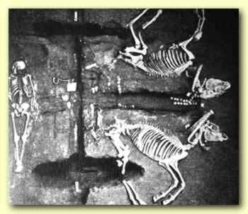
Who were they:
It
has been suggested from a series
of horse burials, that this site
has produced
evidence that the cities could
have been the home of the Aryans.
Several ancient Indian texts
believed to have been written by
Aryans recount similar rituals.
"These ancient Indian texts and
hymns describe sacrifices of
horses and burials and the way
the meat is cut off and the way
the horse is buried with its
master ... If you match
this with the way the skeletons
and the graves are being dug up
in Russia, they are a
millimetre-perfect match."
(3)
If archaeologists confirm the
cities as Aryan, they could be
the remnants of a civilisation
that spread through Europe and
much of Asia. Their language has
been identified as the precursor
of modern Indo-European tongues,
including English. Words such as
brother, guest and oxen have
been traced back to this
prototype.
"Potentially, this could rival
ancient Greece in the age of the
heroes," said British historian
Bettany Hughes, who spent much
of the northern summer exploring
the region for a BBC radio
program, Tracking the Aryans."We are all told that there is
this kind of mother tongue,
proto-Indo-European, from which
all the languages we know
emerge.
(3)
Sintashta-Arkaim
Culture:
Several years ago
archaeologists considered all
sites of the second half of the
2nd millennium B.C. as belonging
to the Andronovo culture. Within
the last decade, two additional,
and yet more ancient cultures
were discovered in Eurasia that
have several characteristics in
common. These were named "Petrovka"
and "Sintashta." Located in the
southern Ural region, they are
dated to c. 2000-1600 B.C. (Gening,
Zdanovich 1993, Zdanovich 1995,
1997) The former occupied the
eastern region (Tobol -Ishim),
and the latter the southern
area. Previously, Sintashta
settlements had been excavated
but they had not been understood
because of their difference from
the classical Andronovo culture.
Moreover, because the complexes
contained some features
belonging to the Abashevo
culture, the original
researchers had initially
included them into the Abashevo
sphere.
The most diagnostic
feature of the Sintashta
settlement site is its closed
fortification that consisted of
ramparts and ditches, enforced
by a fence or wall built from
unfired clay bricks and wooden
frames. The site plan was based
on either a round or rectangular
form. The fortified area
included from 6,000 to 30,000
sq. meters. Towers and other
constructions protected the
entrances and the accesses to
water (Zdanovich 1995). The
houses were 25-130 sq.meters,
rectangular and had pit-storage,
open fire hearths, wells. Some
also included metallurgical
furnaces.
Why had the individuality
of Sintashta sites and their
associated artifacts not been
recognized earlier? And why are
the sites still the subject of
dispute? The crux of this matter
is that frequently the more
ancient deposits had been
destroyed by subsequent layers
of occupation. It was possible
to understand the Sintashta
settlement only after a another
site had been investigated more
recently.
The Sintashta sites have
been referred to as "The Land of
Towns " (Gening, Zdanovich 1993,
Zdanovich 1995). The cultue had
occupied the territory along the
eastern slopes of the Ural
Mountains. The fortified
settlement studied in most
detail is Arkaim. Occupying
20,000 sq. meters, it was
discovered in 1987 by the team
headed by G. Zdanovich during
salvage excavations before the
construction of a dam. The
excavation revealed that the
settlement had been burned and,
therefore, many details were
preserved. The population,
however, had vacated the city
before the fire and took all
their possession with them.
Arkaim had two protective
circular walls and two circles
of standard dwellings separated
by a street around a central
square. The external wall, 160 m
in diameter and 4 m wide, was
built from specially selected
soil that had been packed into
timber frames before being faced
with adobe bricks (Zdanovich
1997). On the interior, houses
abutted the wall and were
situated radially with their
doors exiting to the circular
internal street.
Many interpretations have
been suggested in relation to
this site - a military fort,
proto-city, or a ceremonial and
religious center. The latter
hypothesis appears reasonable,
if we bear in mind that the sets
of artifacts excavated were not
characteristic of everyday
usage. More plausible are the
nterpretation put forward by
researchers who regard sites
such as Arkaim as combination of
administrative and ceremonial
centers. Possibly this was a
location where about 1,000 to
2,000 people�aristocracy (and
craftsmen) gathered
periodically to perform
rituals.
(4)
Astronomy:
The
similarity of latitude, date, and size led some
astronomers (Bystrushkin 2003) to compare Arkaim
with
Stonehenge in England. According to their claims, the
Neolithic observatory at Stonehenge allowed for observation
of 15 astronomical phenomena using 22 elements, whereas the
contemporaneous observatory at Arkaim allowed for
observation of 18 astronomical phenomena using 30 elements.
They include sunsets and sunrises on the days of equinox and
solstice, as well as sunsets and sunrises during low and
high Moon. (1)
The precision of measurements in Stonehenge is estimated at
10 arc-minutes to a degree, that in Arkaim being put at 1
arc-minute. (2)
(The
Caucasus Dolmens)
(Index
of Ancient Sites) |