|
 Prehistoric Peru:
(The Land of the Four Quarters)
It is a peculiar fact,
common to many ancient ancient cultures, that the oldest civilisations were
the most advanced, at the same time as possessing the highest style of art and mechanical skill.
This is true of Peru.
Baldwin says of Peru in his 'Pre-historic Nations'; 'The
oldest structures were attributed to bearded white men, who it is said,
worked stone with iron implements brought from their own country. The
traditions call them 'sons of the sea'. It is a remarkable fact, not
generally known, that the Incas worked iron mines on the east side of Lake
Titicaca. (see introduction to Popl-Vuh p.224). Planet worship, temples of
the sun, and a great knowledge of astronomy existed in Peru at a very early
period. Montesinos and De Bourbourg say the Peruvians had an accurate
measure of the solar year, and a knowledge of the art of writing, together
with paper made of banana leaves at least 1800 years before our era'. (2)
|
Featured Peruvian Locations: |
|
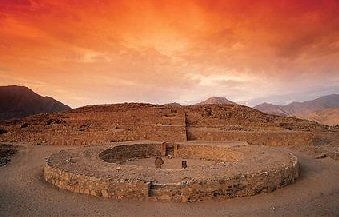 Caral-Supe
Complex. Caral-Supe
Complex.
At 2,600 BC,
this is the oldest centre of civilisation in the Americas.
A quipu (the knot system used in Andean civilizations to record
information) found on the site testifies to the development and
complexity of Caral society. The city�s plan and some of its
components, including pyramidal structures and residence of the
elite, show clear evidence of ceremonial functions and
monumental architecture, including six large pyramidal
structures.
(More
about the Caral Pyramid Complex) |
|
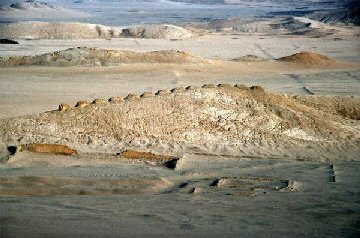 Chankillo
Landscape Observatory Chankillo
Landscape Observatory
The Thirteen Towers of Chankillo run north to south along a
low ridge within a fourth-century B.C. ceremonial complex in
north coastal Peru. From evident observing points within the
adjacent buildings to the west and east, they formed an
artificial toothed horizon that spanned the annual rising
and setting arcs of the Sun.
At present, the
culture that made them has not been named.
(More
about the Chankillo Observatory)
|
|
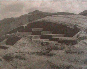
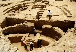 Sechin
Alto complex - This almost unnoticed U-shaped ceremonial
complex is one of the largest of all early monuments in the
Americas. It includes both a colossal, stone-faced platform which
stands 40m high and measured 300m x 250m at the base, and the
large sunken plaza called the 'Serro Sechin' with
architectural resemblances to both Tiahuanacan culture to the
south and Olmec remains from the north. Sechin
Alto complex - This almost unnoticed U-shaped ceremonial
complex is one of the largest of all early monuments in the
Americas. It includes both a colossal, stone-faced platform which
stands 40m high and measured 300m x 250m at the base, and the
large sunken plaza called the 'Serro Sechin' with
architectural resemblances to both Tiahuanacan culture to the
south and Olmec remains from the north.
The Plaza in
the photo (Left) is dated at 3,500 BC, other structures have been
found beneath it, making it one of the earliest of its kind in the
Pre-Columbian Americas.
(5)
(More
about the Sechin Complex) |
|
 Chavin
du Huantar
-
Capital of the Chavin culture.
Chavin du
Huantar, is an unusual complex
of steeply walled platforms, honeycombed with stone-lined passages surrounding a sunken plaza. It is unique amongst Pre-Columbian temple
groups. The principle edifice, called 'The Castillo' is faced with cut-stone
blocks in courses of varying widths. Inside the core are at least three irregular storeys of
stone-lined galleries, chambers and ventilating shafts.
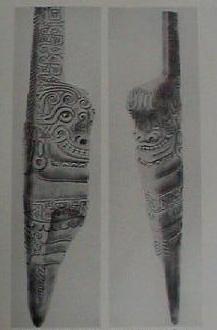
There are still several engraved obelisks as Chavin du Huantar. Perhaps the
most incredible (Right), called 'El-Toro' (the Bull), or 'Lanzon'
(the Lance), was originally situated in the centre and deep in the underground catacombs at Chavin de Huantar. The top of it, at 4.5m, protruded through the
ceiling, and the floor above.
(More about Chavin du Huantar)
|
|
 Cuzco
(Cusco)
- The
capital of the Inca empire.
The name
Cuzco
means 'Navel' in Quechua, with the site being considered the 'earth-navel'
of the Incas nations.
Tradition describes the founders of Cuzco
as two 'children of the Sun'. Manco Capac and
Mama Occlo Huaco, who were both brother and sister and husband and wife.
Sent by the Sun, the couple advanced from lake Titicaca with a golden
wedge, which was destined to sink into the earth without any effort at
their final place of residence, which was Cuzco
Cuzco is the centre of a network of
spirit-paths (cerques), that radiate across the landscape.
(More about
Cuzco)
|
|
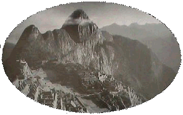
Machu Pichu
- This Pre-Columbian Inca mountain
citadel was only rediscovered in 1911. It shows several strong
indications of astronomical observation.
The structures are built from white
granite, with blocks reaching up to 3.7 metres in length.
Location of the famous Intihuatana stone, also called
"The Hitching Point of the Sun" because it was believed to hold
the sun in its place along its annual path in the sky. At midday on
March 21 and September 21, the equinoxes, the sun stands almost above
the pillar�casting no shadow at all.
Skeletal remains show a 10:1 ratio of females to males.
(3)
(More about Machu Pichu) |
|
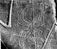
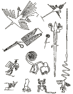 Nazca
- Probably the best known example of landscape design in the ancient
world. These drawings in the desert have prompted much debate and wonder
since their discovery. Nazca
- Probably the best known example of landscape design in the ancient
world. These drawings in the desert have prompted much debate and wonder
since their discovery.
The Nazca valley is a strip of
level desert ground 37 miles long and a mile wide. The enormous drawings
were made by removing the dark granite pebbles which cover the floor,
and exposing the light yellow sand below. The drawings were first confirmed
when commercial airlines began flights over the Andes. They are clear enough
to have been viewed by astronauts aboard Skylab, orbiting 270 miles above
Earth.
There are essentially
two kinds of drawings at Nazca; Those that are Zoomorphic in
nature (left), and the larger geometric ones, some of which run into the
surrounding hills. The purpose of these designs is still unknown,
although astronomy and a form of ritual worship is suspected.
(More about Nazca) |
|
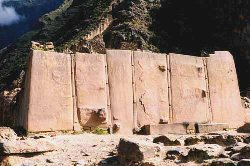 Ollantaytambo
(Ollantiatambo) -
A
Pre-Inca
fortress, with rock walls of tightly fitted blocks weighing
between 150 and 250 tons each. Most of the blocks are andesite, the
quarries for which are situated on a mountain-top seven miles
distant. As well as the difficulties
experienced in dressing the stones, they had to be lowered down
one mountain, over a river canyon with 1000 ft sheer rock walls,
then raised up the mountain the complex is situated on. Ollantaytambo
(Ollantiatambo) -
A
Pre-Inca
fortress, with rock walls of tightly fitted blocks weighing
between 150 and 250 tons each. Most of the blocks are andesite, the
quarries for which are situated on a mountain-top seven miles
distant. As well as the difficulties
experienced in dressing the stones, they had to be lowered down
one mountain, over a river canyon with 1000 ft sheer rock walls,
then raised up the mountain the complex is situated on.
The six Porphyry stones (right),
are some of the largest at the site, they weigh approximately 50 tons each.
One of the stones has the remains of a 'stepped -lozenge' motif on its face. The same (horizontal)
motif is also found in
Tiahuanaco.
(More about Ollantaytambo)
|
|
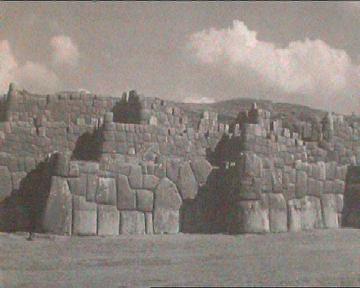
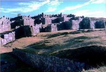 Sacsayhuaman
-
Located on the outskirts of the ancient Inca capital of Cuzco.
Sacsayhuaman rests on an artificially levelled mountaintop, and
consists of three outer lines of gargantuan walls, 1,500 ft long
and 54 ft wide, surrounding a paved area containing a circular
stone structure believed to be a solar calendar. The ruins also
include a 500,000 gallon water reservoir, storage cisterns, ramps,
citadels and underground chambers. Sacsayhuaman
-
Located on the outskirts of the ancient Inca capital of Cuzco.
Sacsayhuaman rests on an artificially levelled mountaintop, and
consists of three outer lines of gargantuan walls, 1,500 ft long
and 54 ft wide, surrounding a paved area containing a circular
stone structure believed to be a solar calendar. The ruins also
include a 500,000 gallon water reservoir, storage cisterns, ramps,
citadels and underground chambers.
The stone blocks weigh from between 50
tons to over 300 tons.
Common to many prehistoric examples of masonry, all the blocks
were fitted together so precisely that a thickness gauge could not
be inserted between them.
A Block on the outer walls, has faces cut
to fit perfectly with 12 other blocks. Other blocks were cut with
as many as 36 sides.
(More about Sacsayhuaman) |
Moseley
(4), demonstrates that although
the geographical region of Peru has been occupied since the 'Lithic
period' (c. 8,000 B.C.), the foundations of civilisation do not appear
until much later. However, recent discoveries have pushed his estimate
of human occupation back to 10,000 B.C.
(8)
Article:
ScienceDaily (May 23, 2011) :
'South
America's Oldest Textiles Identified With Carbon Dating'.
'Textiles and rope
fragments found in a Peruvian cave have been dated to around
12,000 years ago, making them the oldest textiles ever found
in South America, according to a report in the April issue
of
Current Anthropology'
Article:
ABC News (Dec, 2010):
'12,000 Year Old Mine Found in
Peru'.
'Archaeologists from the University of Chile have discovered a
12,000-year-old iron oxide mine in the north of the country.
Researchers say it is the oldest mine discovered in all the
Americas. Chief researcher Diego Salazar said the iron oxide was
used by Huentelauquen Indians as a pigment in dying cloth and in
religious rituals. the mine was exploited heavily between around
10,000 BC and 2,000 BC. It yielded over the millennia a total of
2,000 tons of pigment extracted from 700 cubic metres of rock.
Researchers also found a treasure trove of stone and conch
mining tools in the area. "We've found more than 1,000 hammers
... but considering the amount of material we have yet to sift
through, the real number could rise to several thousands,"
archaeologist Hernan Salinas said. Before this find, the oldest
mine in the Americas was 2,500 years old and located in the
United States'.
(8)
(More about
Prehistoric Mining)
The 'Inca' Origin Myth.
The oral tradition of the Inca stated that the
creator, called Viracocha, had caused the sun to emerge from the waters
of Lake Titicaca. He then went to the ancient lakeside metropolis of
Tiahuanaco, which had been formerly inhabited by a race of giants. There
he gathered primordial clay and modelled animals and people. The creator
ordered the people to descend deep into the earth and mountains and then
to emerge separately from different caves, springs, lakes and hills in
different homelands.
According to some stories, the founder of the Inca
royal family, Manco Capac, along with his three brothers and four
sisters, emerged from Titicaca, while in other versions they emerged
from a cave southeast of the Rio Huantanay. Gathering a small following,
the siblings set off in search of a place to settle. Following a long
and adventurous journey, several of the brothers become embedded in
stone or entombed in mountains. Eventually, Manco Capac and his
sister/wife arrived near the spot where the Rio Tullamayo joins the
Huantanay. Here the founder plunged his 'golden staff' into the soil to
test it. Finding it auspicious, they established a settlement there
which would become the Coricanha. After founding Cuzco and establishing
a family, Manco Capac turned to stone. This ancestral stone became one
of the Incas' most sacred objects or ' Huacas'.
(4)
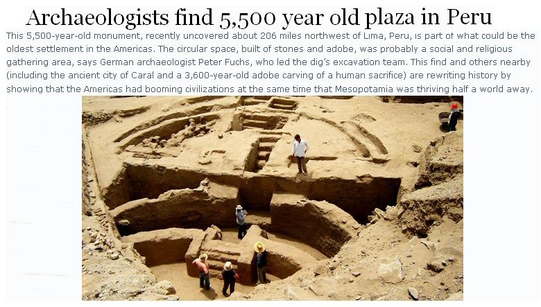
(More
about the Sechin Complex)
An intensive study of the Viru Valley on the North coast, showed a
cultural sequence going back to 2,500 BC
(1).
When Pizarro (and his force of only 260 Spanish mercenaries) conquered
Peru in 1532, the Inca realm was one of the largest empires on earth, but it
had already been preceded by the Chavin, Moche, Nazca, Tiwanaku, Huari and
Himu civilisations.
The 'Inca' refers only to a small group of kindred, less than 40,000
individuals, who built the great Andean state by force of arms, and who
ruled as the realms governing nobility.
At the height of their empire, their rule extended to over 10 million
people. These individuals were Inca subjects, but they were not Incas
because they were a closed ethnic body.
(4)
|
Extreme Peruvian Masonry
At Torontoy, one of the smaller sites clustered around Machu Pichu,
there is a stone with 40 angles between the sides.
(3).
The Inca
were able to create citadels such as Mach Pichu, Cutting through granite,
with intricate block-work, yet no tools have been found that explain how.
The Quartz beads in the
picture on the left were discovered on a Peruvian mummy. The beads are so
small that it was claimed we were unable to reproduce the holes that were 'originally
drilled' through them, with current technology (1970's). A
remarkable achievements, regardless.
(Other examples of extreme masonry)
|
|
List and Description of Peruvian Stites: |
In 1964, aerial photography identified
nearly 1,000
pyramid
sites in Peru
(1)
Underground tunnels.
Peruvian Andes, Huascaran, 22,203 ft high, near the village
of Otuzco.
Cave entrances closed with slabs of rock. First recorded by
Francis Pizzaro (1478-1541). An expedition was organised in 1971, an
account of which was given in the periodical �Bild der Wissenschaft�.
� Vast tunnels which would leave even modern underground
constructors green with envy began behind six �doors�. These tunnels lead
straight towards the coast, at times with a slope of 14 per cent. The
floor is covered with stone slabs that have been pitted and grooved to
make them slip-proof. It is an adventure even today to penetrate these 55
to 65 mile-long transport tunnels in the direction of the coast and
finally reach a spot 80 ft below sea level. The great ocean lurks at the
end of the underground passage of �Guanape�, so called after the island
that lies off the coast of Peru here, because it is assumed that the
passages once led under the sea to the island. After the passages have
gone uphill and downhill several times, and after a downhill slope, they
end in ocean water".
(18)
(Other
Underground Structures)
|


 Caral-Supe
Complex.

 Sechin
Alto complex - This almost unnoticed U-shaped ceremonial
complex is one of the largest of all early monuments in the
Americas. It includes both a colossal, stone-faced platform which
stands 40m high and measured 300m x 250m at the base, and the
large sunken plaza called the 'Serro Sechin' with
architectural resemblances to both Tiahuanacan culture to the
south and Olmec remains from the north.

 Nazca
- Probably the best known example of landscape design in the ancient
world. These drawings in the desert have prompted much debate and wonder
since their discovery.


