|
Location: 5 km from Casma,
Ancash, Peru. |
Grid Reference:
9.45� S, 78.23� W |
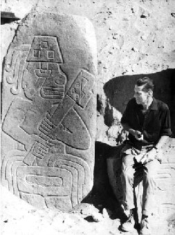
 The
Sechin Complex:
(Casma Valley Complex).
The
archaeological site called Sechin Alto is home to the largest
pre-Columbian monument in Peru.
The Sechin complex in the Casma
Valley was the capital of a pre-Incan culture located on the
northwest coast of Peru, occupied between approximately 1,800-900
BC.
The significance of these early dates
means that it preceded the much better known site of
Chavin de Huantar by nearly a
thousand years rather than visa versa as had been thought
previously.
The
site is remarkable for its enormous mound, the largest of its time
period, measuring some 990 feet long, by 825 feet wide by 145 feet
tall. The mound
was faced with granite blocks, some weighing over 2 tons. Sechin
Alto's great size may represent a 1000 year building span.
|
The Casma Valley 'Setchin' Complex: |
The Sechin Complex was a vast
proto-urban settlement several miles in diameter, centred on the large
mound of Sechin Alto. It included the sites of Sechin Bajo,
Taukachi-Konkan, and Cerro Sechin.
The similarity in mound forms and site
layout of Sechin Alto, Taukachi-Konkan, and Sechin Bajo, combined with
the coincidental orientation of all three sites both provides evidence
of contemporaneity of the sites and suggests that they may once have
formed part of a single, large, continuous settlement which occupied
land on both sides of the Sechin River, being now interrupted by
modern civilisation. (2)
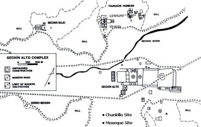
Sechin Alto is
believed to be part of the larger Sechin Alto Complex that covers some
4 square miles (10.5 sq km) and includes three other sites�Sechin Bajo,
Taukachi-Konkan, and Cerro Sechin. These sites all share a coincident
architectural orientation up the valley and have architectural traits
in common, such as rounded corners, circular courts, and the use of
cone-shaped adobes. (1)
Sechin
Alto is located on the left margin of the Sechin River, along the road
to Huaraz. This temple site is the largest of the Pre-Columbian
monuments of Peru, and is the largest of the Casma Valley structures.
It was constructed from dressed stone and "conical" style adobe, with
a U-shaped monument plan covering about 200 hectares. Five plazas
extend about a mile (1.4 km) from the huge central mound, three with
central sunken courts, one of which is about 250 ft (80 meters) in
diameter. The main mound is 44 meters high by 300 meters by 250
meters., making it the largest single construction in the New World
during the second millennium B.C.
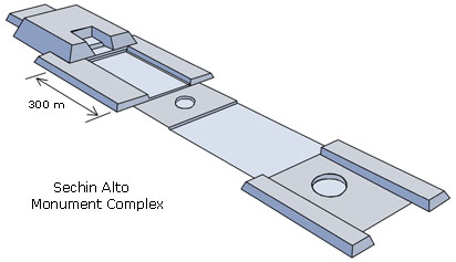
Its alignment is
magnetic E32 N, and the main entrance is up-valley towards the
northeast. All of the outlying mounds are coincident with respect to
orientation, and most examples with distinguishable features are also
generally U-shaped. The construction materials for the Sechin Alto
mound consists mainly of granite blocks quarried from hillsides about
2Km to the south, all of which were wet-laid with a silty clay mortar.
Many of these blocks, especially along the main mound face are huge,
measuring over 1.5 metres. (2)
Julio Tello was the first archaeologist
to survey Sechin Alto in the late 1930s;
In
1956, brief testing by
Donald Collier and Donald
Thompson yielded two radiocarbon dates of ca.
690
B.C. and ca. 1450
B.C. that were in reverse order
compared to the excavation stratigraphy. Nevertheless, architectural
and ceramic data from later surveys in
1968 by Rosa Fung
and Carlos Williams and in
1980 by
Shelia Pozorski and
Thomas Pozorski indicate that Sechin Alto and the larger Sechin
Alto Complex date to the Initial Period (1800�900
B.C.).
(1)
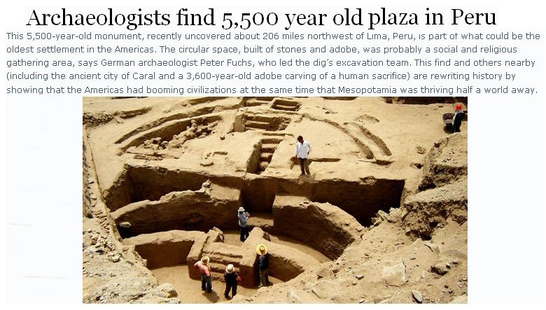
New ruins found at
Sechin Bajo.
(Read
Full Article)
Slighty northwest of
the site of Sechin Alto, and clearly visible from the top of its main
mound. Although the clusters of mounds and plazas on either edge of
the plain were formerly treated as separate sites (Thompson 1961:
211-217), an examination of air photographs revealed a set of
connected and associated architectural features. The total complex
covers an area of about 1250m by 500m.
As at Sechin Alto,
most of the structures are constructed of granite blocks quarried from
nearby hillsides; all of the blocks were laid in a silty clay mortar.
The constructions were also orientated along an axis of E32 N.
Inhabited for much of
the second millennium B.C., Cerro Sechin has been the most intensively
studied site in the Sechin Complex. It covers roughly 50,000 meters
squared and consists of a quadrangular three-tiered stepped platform
flanked on each side by two smaller buildings. The platform was
constructed in several stages using conical adobes, or large sun-dried
bricks with broad circular bases and tapered points, which were then
set into clay mortar and plastered over to form wall surfaces.
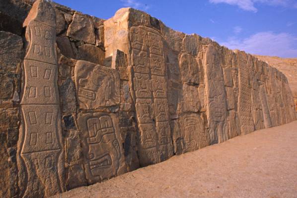
The retaining wall,
roughly 4.15 meters (13.5 feet) tall and containing nearly 400 granite
sculptures, was added relatively late in the site's history and
encircled the perimeter of the building. The stone sculptures,
undoubtedly the most famous feature at Cerro Sechin, depict a possible
mythological or historical scene in which a procession of armed men,
probably important personages or warriors, make their way among the
mutilated remains of human victims. Given the gruesome nature of the
stone frieze, it seems likely that some degree of warfare, violence,
and/or raiding existed among these early valley peoples.
Though little is
known about Cerro Sechin's demise, the site appears to have been
abandoned by 800 B.C., paralleling the decline of other important
ceremonial and public centres on the Peruvian coast at this time.
|
The Chankillo: Astronomical Observatory: |
The Sechin Valley
is also home to the
enigmatic, 2,300-year-old ruin named the 'Chankillo'. Archaeologists
have nicknamed the ruin�s central complex the �Norelco ruin� based on
its resemblance to a modern electric shaver. The building�s true
purpose long eluded them. Its thick walls and hilltop location
suggested it was a fort, but why, researchers wondered for a long
time, would anybody build a fort with so many gates and without a
water source?
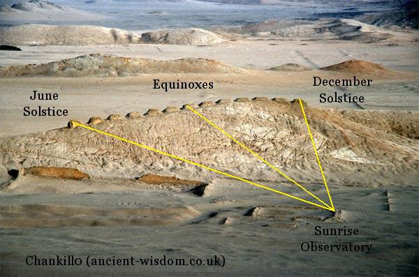
The Thirteen Towers
on a nearby ridge were the key to the scientists conclusion that the
site was a solar observatory. The gaps between the towers are wide
enough for just one or two sunrises to be observed in each. The
regularity of the gaps suggests that the year was divided into regular
intervals.
These regularly
spaced towers line up along a hill, separated by about 5 meters (16
feet). The towers are easily seen from Chankillo�s central complex,
but the views of these towers from the eastern and western observing
points are especially illuminating. These viewpoints are situated so
that, on the winter and summer solstices, the sunrises and sunsets
line up with the towers at either end of the line. Other solar events,
such as the rising and setting of the Sun at the mid-points between
the solstices, were aligned with different towers.
(3)
(More
about the Chankillo Observatory)
|


