|
Location:
12 Miles from lake Titicaca, Bolivia. |
Grid Reference:
16.55˚ S 68.67˚ W |
 Tiahuanaco:
(Tiwanaku).
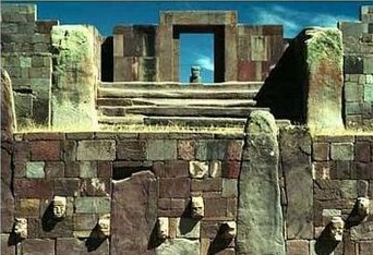
Tiahuanaco sits in the Bolivian Andes at a height of over 12,500 ft.
It was once one of the most significant complexes in the pre
Columbian Americas.
Inca tradition spoke of the founding Inca male and female coming
to Cuzco
from the 'Island of the Sun' on Lake Titicaca, nearby.
(1)
When the Spanish first encountered
Tiahuanaco in the sixteenth century, they went to great efforts to destroy
it. Early in the 20th century, Bolivian railway workers broke up
many of the blocks as ballast for the railway beds. The remains
of the site are now finally being restored.
(1) (1877
Description of Site)
(Click here for interactive map of the site)
|
Tiahuanaco: General Overview of the Site. |
Tiahuanaco sits high in the Andes at an
altitude of around 2 miles above sea level. The location is
curious as a lake nearby to lake Titicaca, with which the site
is associated, is a sea-water lake, apparently with
sea-fauna still present. Indications of man-made structures
below the level of lake Titicaca (which is slowly drying up over
time), suggests that our understanding of the site is far from
complete.
In addition, the style, size and skill
demonstrated by the vast number of precision-cut cyclopean
stones at Tiahuanaco (and nearby Puma-punka) reminds us that
cutting and moving 100+ ton stones was common-place for the
highly skilled builders of the complex, who also managed to move
the stones over tens of miles from distant quarries to
Tiahuanaco, which at such a high altitude is in itself, a
remarkable physical feat.
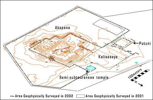
The mythology of the Incas relates that
Titicaca was the birthplace of the Inca nation, further adding to
its importance.
|
Chronology of Tiahuanaco: |
Although a date of extreme antiquity is often suggested,
carbon-14 dates from the site place the construction at no earlier
that 1,700 BC. A date which was greatly contested by the
Archaeologist Posnansky who spent 50 years researching the site,
and who became determined through archaeo-astronomy that it was
either built at an earlier time, or built over pre-existing
constructions (also from an earlier time).
Prof. Posnansky
summed up his 50 year study in a 4 volume work entitled Tiahuanaco, The cradle of American Man first published in
1945. He based his theories on the astronomical phenomena known as
"obliqueness of the ecliptic" (not to be confused with the other
astronomical phenomenon known as "Precession".
Since the Earth is tilted on its axis in respect to the plane of
the solar system, the resulting angle when viewed from earth
causes the
planets of our solar system to travel across the sky in a line called
the plane of the ecliptic.
At present our earth is tilted
at an angle of around 23 ˚
27'
00", but
this is not constant. The earth's axis oscillates slowly between
22˚
01' 00" to an extreme of 24˚
05' 00".
This cycle (repeating itself from one extreme to the other and
back) takes roughly 41,000 years to complete. The alignments at
the Kalassaya temple suggest a tilt of the earth's axis amounting
to 23˚
8' 48", indicating a date of 15,000 B.C.
This date is generally not accepted by archaeologists,
and indeed conflicts with another strong theory on the table at
the moment; that of Crust-shift-displacement. For example, on one hand Posnasky says that Tiahuanaco dates
back to 15,000 BC, and on the other, Hapgood (and Einstein) talk of
crust-shift-displacement, which would have the effect of displacing any
cardinally orientated structures. Should this theory ever become
realised as fact, it will have to be accepted that structures such
as Tiahuanaco and the Sphinx etc, were built after the
last displacement (suggested as 10,500 BC), which means that either the earth-crust-displacement
theory is wrong or Posnasky is... figure it out for yourself..
Carbon-14 Dating puts the
first period of Tiahuanaco back to 1,700 BC, the second period to 360 BC,
and the third era from 133-374 AD to 1,200 AD
(1).
The city was the administrative and
religious heart of a pre-Incan civilisation that began in the year
237 BC and endured for over 1400 years. During its peak (724- 1172
AD) the Tiahuanacan Empire covered nearly all of Bolivia, Northern
Chile and Southern Peru, ruling over more than three million
subjects. (2)
|
Tiahuanaco Constructions: |
|
The Akapana:
The Akapana pyramid was once a
seven-step pyramid measuring some 200 meters on each side and
standing nearly 17 meters tall. Like the nearby Subterranean
Temple and the Kalasasaya, the Akapana was precisely oriented to
the cardinal directions. Each of the seven levels was constructed
with beautifully cut and precisely joined andesite blocks (of
which 90% are now missing), that were faced with panels once
covered with metal plaques, carvings, and paintings. In the centre
of the Akapana�s flat summit is a small, sunken courtyard laid out
in the form of a square superimposed over a perfect cross; this
courtyard was also oriented to the cardinal directions. Recent
excavations of this courtyard, the interior of the pyramid, and
the grounds beneath it have revealed an unexpectedly sophisticated,
and monumental system of interlinked surface and subterranean
channels. These channels brought water collected upon the summit
down and through the seven levels, where it exited below ground
level, merged into a major subterranean drain system underneath
the civic/ceremonial core of Tiwanaku, and ultimately flowed into
Lake Titicaca
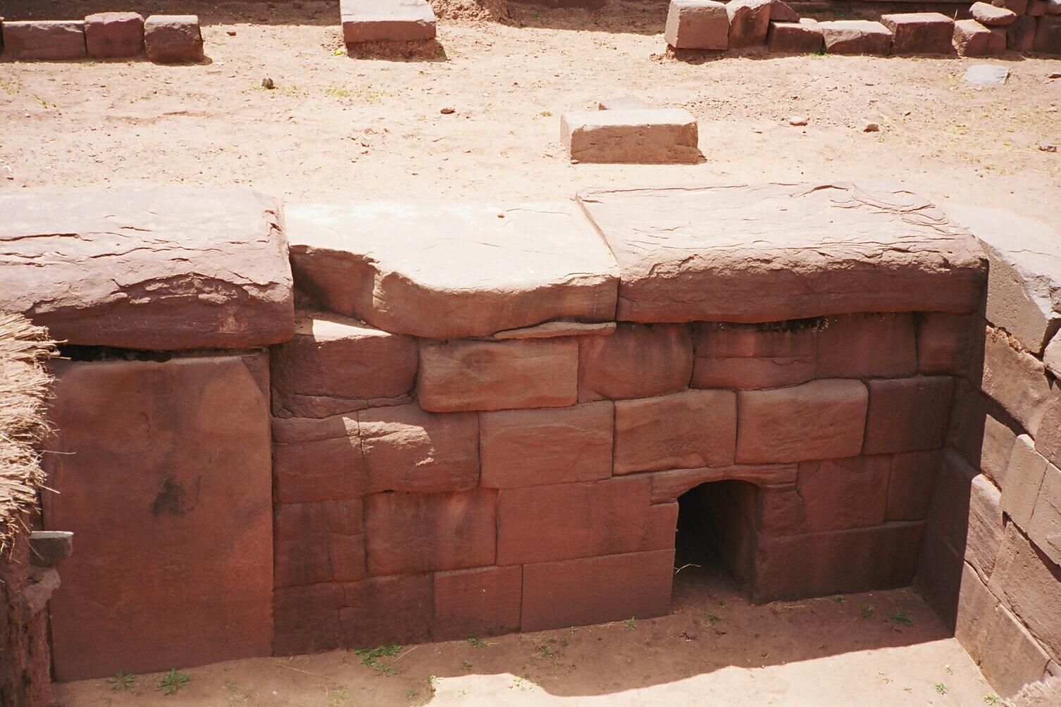
A drainage hole at the base of the destroyed pyramid. |
The Kalasasaya: ('The Standing Pillars', 'Place of the
vertical stones')
The Kalasaya is
a raised rectangular enclosure measuring about 450 feet by 400 feet,
built like a stockade with 12 foot high columns
jutting upward at intervals, each of these being carved into human figures.
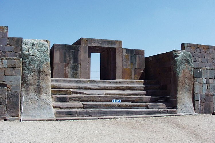
The grand entrance of the Kalasasaya.
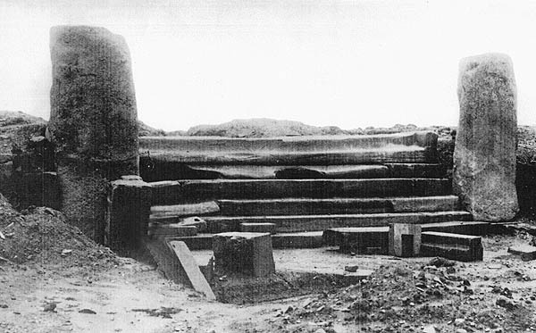
The entrance as it was when it was
first discovered.
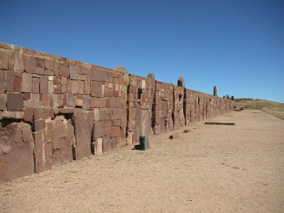
The walls of the Kalasasaya are built in the same style as
the semi-submerged temple, which opens out before it. Unlike the
semi-submerged temple, the Kalasasaya is a semi-raised edifice, with the
space inside the walls being filled in.
As part of Posnansky`s studies, he conducted precise surveys of all
the principal structures of Tiahuanaco. The Kalasasaya structure,
was delineated by a series of vertical stone pillars (the name
Kalasasaya means "the standing pillars") and had an east-west
orientation. Utilizing his measurements of the lines of sight along
these stone pillars, the orientation of the Kalasasaya, and the
purposely intended deviations from the cardinal points, Posnansky
was able to show that the alignment of the structure was based upon
an astronomical principle called the obliquity of the ecliptic.
|
|
The Monoliths (Stelae):
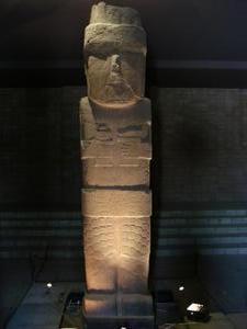
The largest Stelae at Tiahuanaco (Right)
is 7.3m high (20 ton), Bennett monolith, or 'Pachamama', which stood
for several years in front of Le Paz stadium was taken in 1932 and returned
2002. The lower half of its body, which is covered with
fish-scales (which upon close inspection are actually fish-heads),
immediately reminds one of the Mesopotamian deity called Oannes, the
man-fish amphibious being who conveyed special knowledge to ancient mankind.
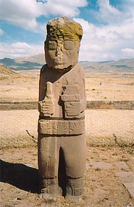
(left) - The red
andesite monolith ('El
Fraile, 'The Friar'), was found
there as was the remaining smaller monolith of a bearded figure
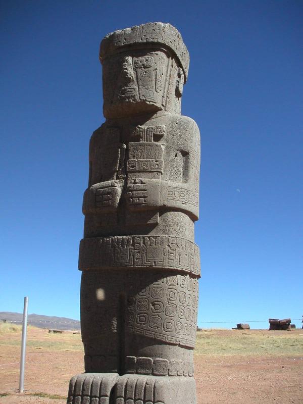
The Ponce monolith (Right), named after its discoverer Wendell
Bennett, was found in the centre of the semi-submerged temple (see below).
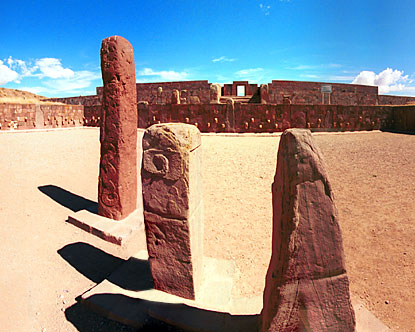
Three more in the semi-subterranean temple...
|
|
The Semi-subterranean
Temple:
The Subterranean Temple, was studded with
sculptured stone heads set into cut-stone facing walls and in the
middle of the court was located a now-famous monolithic 'Bennett'
stela, Named for archaeologist Wendell C. Bennett who conducted the
first archaeological research at Tiahuanaco in the 1930's, the
Bennett Stela represents a human figure wearing elaborate clothes
and a crown.
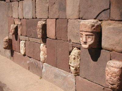 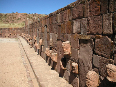
It is noticeable that all the stones are of different colours and sizes.
Note: The lower heads seem to be considerably more worn than the upper
ones?
Similar building techniques can be seen at both
Serro Sechin and Chavin Du Huantar
in Peru.
|
|
The Gateway of the sun -
(Puerta del Sol):
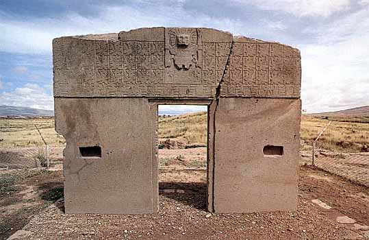
The 10 ton Gateway of the Sun is monolithic, carved from a
single block of Andesite granite, now broken right down the
center. It now stands in the NW corner of the Kalasasaya,
although it was found fallen and completely covered in mud
elsewhere on the site.
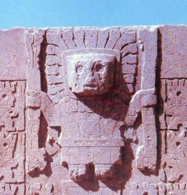
A close-up of the crying sun-god symbol... |
|
Tiahuanaco - Other Points of Interest: |
Roughly fifteen miles from Tiahuanaco, this lake is believed
to have once extended to the city. The highest navigable water in
the world. Its present fauna (including a species of sea horse),
a nearby salt-water lake, and the angle of an ancient shore-line have led scientists
to consider that the lake may have once been attached to the sea, following
which it was raised to its present
height.
On the rock
cliffs near the piers and wharfs of the port area are yellow-white
calcareous deposits forming long, straight lines indicating
pre-historic water levels. These ancient shorelines are strangely
tilted, although once they must have been level.
Athough the lake averages between 460 and 600 feet (140 and 180 m)
in depth, but the bottom tilts sharply toward the Bolivian shore,
reaching its greatest recorded depth of 920 feet (280 m) off Isla
Soto in the lake's northeast corner.
On Titicaca Island the ruins of a temple
mark the spot where, according to the tradition of the Incas the
founders of the Inca dynasty, Manco Capac and Mama Ocllo,
depending on which variation one hears, were either sent down to
Earth by the Sun or emerged from the depths to found their empire.
(Click
here for map of Titicaca)
Discoveries in the Lake.
In November 1980,
the Bolivian author
and scholar of pre-Columbian
cultures, Hugo Boero Rojo, announced the finding of archaeological ruins
beneath Lake Titicaca about 15 to 20 meters
below the surface off the coast of
Puerto Acosta, a Bolivian port village
near the Peruvian frontier on the
northeast edge of the lake. At
a press conference the Bolivian author stated that:
"we can now say
that the existence of pre-Columbian
constructions under the waters of Lake
Titicaca is no longer a mere
supposition or science-fiction, but a real fact. Further," he added,
'the remnants found show the existence of old
civilizations that greatly antecede
the Spanish colonization. We have found
temples built of huge blocks of
stone, with stone roads leading to unknown
places and flights of steps whose
bases were lost in the depths of the lake
amid a thick vegetation of algae." Boero Rojo described these monumental
ruins as being "of probable
Tiahuanaco origin.
In August 2000, the BBC announced the
discovery of ancient ruins 30m beneath the lake, and confirmed that
a temple had been discovered by following a submerged stone road.
The discoveries are believed to
date
back 1,000 to 1,500 years ago,
and are credited as pre-Incan
confirming that the level of the lake fluctuates periodically.
http://news.bbc.co.uk/2/hi/americas/892616.stm
It has been observed in relation
to this that soil covers the
ancient Tiahuanacan plateau to a depth of
at least 6 feet, under which relics
and artefacts of the ancient culture have been found.
|
The 'Fuenta Magna'.
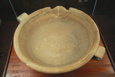
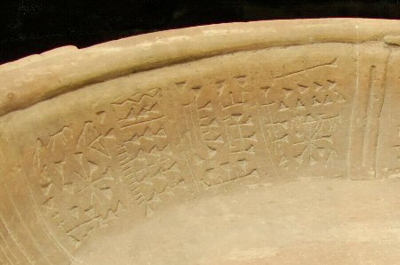
This 'libation' bowl, with cuneiform hieroglyphs on
it was discovered in the 1950's near Tiahuanaco.
The authenticity of the bowl is
challenged by sceptics who claim it to be fabricated by
archaeologists. It now resides in the Museo
De Oro, La Paz.
|
The Puma Punku (Door of the Puma):
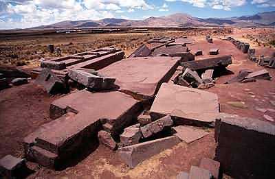
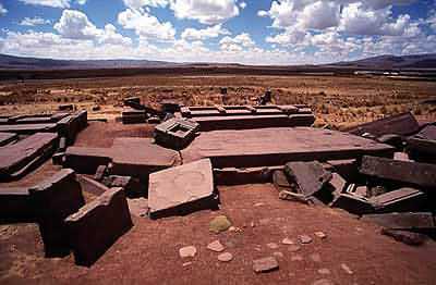
The nearby structure known as the Puma Punka is
still littered with giant, precisely shaped blocks, many of which
appear machine made. The so-called 'port' of Tiahuanaco, called Puma
Punku or "Door of the Puma," which is often quoted to have once been a
wharf with a massive four-part building, is an area filled with enormous
stone blocks scattered around on the ground as though the result of a
catastrophic event. Several
of the bocks are estimated to weigh between 100 and 150 tons.
The means and purpose of transporting such large stones
is still a mystery.
(More about Puma Punku)
(Bolivia
Homepage)
( Pre-Columbian
Americas Homepage)
(Additional
Information on Tiahuanaco at SacredSites.com)
|
|


