|
Location:
Oaxaca Valley,
Mexico. |
Grid Reference:
17� 02' N. 96� 42' W. |
  Monte
Alb�n:
(Zapotec Capital).
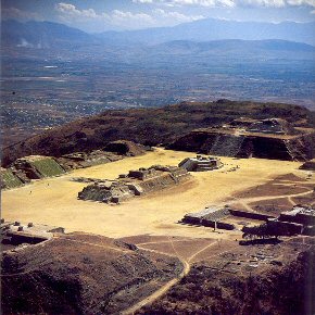
The levelled hilltop on
Monte Alban is the heart of the second largest ceremonial site in
Mesoamerica, and is exceeded in size only by Teotihuac�n. It is believed to have supported up to 35,000 people in its heyday,
revealing it as an important part of the pre-Columbian American landscape.
The site contains some of the
earliest undeciphered hieroglyphs found in all of Mesoamerica.
Although this was one of the most enduring of all the civilizations of
Mexico (lasting from about 500 B.C. to 800 AD), it experienced a sudden
and rapid decline at the same time as the collapse of other pre-Columbian cities elsewhere in
Mexico.
(Click here for map of the site)
|
Monte Alban: (White Mountain): |
The previous names for the city were the Mixtec name "Sahandevul"
which means "At the Foot of the Sky", and another variation which is
derived from the older Zapotecan language, "Danibaan" or Sacred
Mountain".
Monte Alban is
visible from anywhere in the central part of the Valley of Oaxaca
Believed to have been built around 600 BC, the huge complex of ceremonial
buildings on top of Monte Alban mountain has some of the most oddly shaped
structures of the ancient world. Not only was much of the stone brought up
from the valley floor, so was all the water, as the site has no visible
natural source. Blanton's survey of the site
(1), suggests that the
Monte Alb�n hill itself appear to have been uninhabited prior to 500 BC although the valley is
now believed to have been continuously occupied since
2000 BC
There
are a large number of carved stone monuments at
Monte Alban. The earliest examples are the so-called "Danzantes" (dancers),
which represent naked men in contorted and twisted poses, some of them
genitally mutilated. The 19th century notion that they depict dancers is
now largely discredited, and these monuments, dating to the earliest
period of occupation at the site (Monte Alb�n I), clearly represent
tortured, sacrificed war prisoners, some identified by name (see below
for more).
In its
heyday, Monte Alban was the one of the greatest Zapotec 'holy' cities, with
a population of over 30,000 . It is estimated that only about 10% of the site has yet been uncovered.
|
San Jose Mogote. -
(The Forerunner to Monte Alban)
The earliest Zapotec city was San Jose el Mogote, also in the Oaxaca
Valley and founded about 1600-1400 BC; it was abandoned around 500 BC,
when the capital city of Monte Alb�n was founded at the beginning of the
Zapotec heyday. The Zapotecs built their new capital city in the middle
of the valley of Oaxaca, between three populous valley arms and at the
top of this steep hill. Building a city away from major population
centres is called 'disembedded capital' by some archaeologists, and
Monte Alban is one of very few disembedded capitals known in the ancient
world.
San Jos� Mogote is a pre-Columbian archaeological site of the
Zapotec, a Mesoamerican culture that flourished in the region of
what is now the Mexican state of Oaxaca. A forerunner to the
better-known Zapotec site of Monte Alb�n, San Jos� Mogote was the
largest and most important settlement in the Valley of Oaxaca during
the Early and Middle Formative periods (ca. 1500-500 BCE) of
Mesoamerican cultural development.(2)
Situated in the fertile bottomlands of the Etla arm of the Valley
of Oaxaca, the site is located two blocks from the community museum
in the present-day village of San Jos� Mogote, which is about 7.5
miles (12 kilometres) northwest of the city of Oaxaca (Evans
2004:122).
San Jos� Mogote is considered to be the oldest permanent
agricultural villages in the Oaxaca Valley and probably the first
settlement in the area to use pottery. It has also "...produced
Mexico�s oldest known defensive palisades and ceremonial buildings
(1300 B.C.), early use of adobe (850 B.C.), the first evidence of
Zapotec hieroglyphic writing (600 B.C.), and early examples of
architectural terracing, craft specialization, and irrigation
(1150-850 B.C.)..." (3) |
Chronology: Monte Alb�n.
-
Monte Alban Period 1 (650
BC to 200 BC) is known to have had stone buildings, permanent temples,
priests, and an organized religion.
-
Monte Alban Period 2 (200
BC to 1 AD) is characterized by an
influx of a group of people from Chiapas or Guatemala who were smaller
in numbers, but introduced changes as they merged with the resident
population.
-
Between Monte Alban Period 2 (200 BC to 1 AD)
and 3A (100 AD to
400 AD) there is evidence of influence from and trade with Teotihuacan
to the North.
-
Between Monte Alban Period 3A (100 AD to 400 AD)
and 3B (400 AD To
700 AD) the vast majority of the city was reconstructed.
-
Monte Alban Period 4 (800 AD To Spaniards) is the beginning of the
decline of Monte Alban as a major power base in the area.
-
Monte Alban Period 5 reflects the influence of the Mixtec
occupation.
|
Olmecs at the Oaxaca valley.?
It is known that the history of the region started around 4000 years
ago when a village-dwelling people of unknown origin (suggested by some
to have been Olmec colonies) moved into the Oaxaca valleys. Then, around
500 BC (1500 years later) a new people (the Zapotecans) moved into the
region. One of these groups then began the monumental task of levelling
the top of a 1,600 meter high mountain that intersects and divides three
valley, and built Monte Alban with a maze of subterranean passage ways,
rooms, drainage and water storage systems.
Archaeologists may still argue over who founded Monte Alban (in spite
of the oldest reliefs which are clearly Olmec), but what they do agree
on is that in the following centuries, the Zapotecans (the new people to
move into the area) were responsible for the distinct architectural
style and rise to power of Monte Alban (which coincides with the exact
time period that the powerful, war-like Olmec civilization went into
full-scale decline).
It is difficult to believe that any group other than the long
established governing power which controlled the population and
resources of the valleys below would be able to complete the task of
building Monte Alban, or that they would allow a new group of people to
move right into the middle of their territory and take up a dominant
military position on the strategic high ground controlling three
valleys.
Los Danzantes (Building of the Dancers)
is the main highlight of the west side of the plaza.
The oldest known structure at Monte Alban is known as The Gallery of the
Dancers. The glyphs depict naked warriors, ejaculation, childbirth,
dwarfism, captives, the sick, genitally mutilated and the dead with
contorted body positions (like dancers). These pictures are the
oldest artefacts found here and date back to the origins of the city itself.
The distinct artistic style, and the features of the people with round
mongoloid facial features and beards is pure Olmec. The meanings of
these symbols, people, positions, or historical context is open to
interpretation.

One of the strongest characteristics of Monte Alb�n
is the large number of carved stone monuments one encounters throughout
the plaza. The earliest examples, the so-called "Danzantes"
(literally, dancers), were found mostly in the vicinity of Building L. The
19th century notion that they depict dancers is now largely discredited,
and these monuments, dating to the earliest period of occupation at the
site (Monte Alb�n I), clearly represent tortured, sacrificed war
prisoners, some identified by name, and may depict leaders of competing
centres and villages captured by Monte Alb�n (Marcus and Flannery 1996;
Blanton et al. 1996).
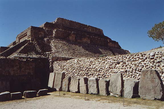
Over 300 �Danzantes� stones have been recorded to
date, and some of the better preserved ones can be viewed at the
site's museum.
These images are clearly of Olmec origin, and similar
contorted figures can be seen at the Olmec capital of
La Venta, which
was occupied from 1200 BC until 400 BC. |
In the centre of the plaza (and presumably of
extreme importance) are two constructions, the largest (in
three sections) was a temple system that included tunnels to other
temples on the site. The second building is the only one not aligned
with the cardinal points and is thought to have been used for astronomy,
hence its name 'The Observatory'. It has several interesting
architectural features.
Building 'J': The Observatory.
A different type of carved stones is found on the nearby Building J
in the centre of the Main Plaza, a building characterized by an unusual
arrow-like shape and an orientation that differs from most other
structures at the site. Inserted within the building walls are over 40
large carved slabs dating to Monte Alb�n II and depicting place-names,
occasionally accompanied by additional writing and in many cases
characterized by upside-down heads. Alfonso Caso was the first to
identify these stones as "conquest slabs", likely listing places the
Monte Alb�n elites claimed to have conquered and/or controlled. Some of
the places listed on Building J slabs have been tentatively identified,
and in one case (the Ca�ada de Cuicatl�n region in northern Oaxaca)
Zapotec conquest has been confirmed through archaeological survey and
excavations (Redmond 1983; Spencer 1982).
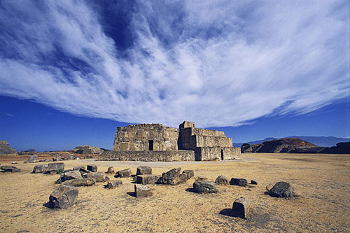
Building J, is interpreted by some scholars as an astronomical
observatory.
(Photo Credits:
sacredsites.com)
The archaeo-astronomer Anthony Aveni has shown how the building's front doorway is precisely
aligned with the point where the bright star Capella (the sixth
brightest in the sky) would have first appeared in the dawn sky each
year, on the same day that the sun reached its first of two
annual zenith days over Monte Alban, on each of which it casts no shadow
at mid-day. The front stairway of J is aligned in turn with Structure P
(on the eastern side of the plaza), which has a unique vertical shaft
leading down into a chamber down which the sun would have shone with no
shadow on that same day. Crossed-stick symbols found on Structure J lend
further support to the importance of astronomical sighting-stick
observations from this position. Moreover, the asymmetric plan of
Structure J turns out to be precisely aligned with the point to the west
where 5 of the 25 brightest stars in the sky, including the Southern
Cross, first rise above the horizon.
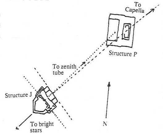
Most structures at Monte Alban are oriented 4
degrees to 8 degrees east of north.
The perpendicular to Structure J's baseline shoots
through what was an opening or doorway in Structure P points northeast
to where the bright star Capella was seen to rise in the processional
era of 275 B.C. During this time Capella made its first reappearance in
the predawn sky (its heliacal rise) on May 8, which is the first solar
zenith passage date at the latitude of Monte Alban. Solar zenith
passages (when the sun passes through the zenith at high noon) were
important indicators of the zenith centre. Solar zenith passages occur
only within the Tropics, that is between latitudes 23.5 degrees S and
23.5 degrees N. Amazingly platform Structure B through which the Capella
observations were sighted, houses Monte Alban's famous zenith tube. This
vertical tube leads into an underground chamber where zenith passage
measurements of the sun and stars could be made. Zenith tubes have been
found at other sites, such as Xochicalco in Central Mexico.
(Article on the Monte Alban Zenith-tube)
(Light-Boxes)
(Archaeoastronomy)
|
The Tombs.
There have been over 200 tombs discovered at
Monte Alban.
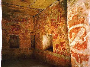
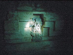
Inside Tomb '104'.
It is interesting to note that in some cases a
rock wheel was used to roll across the entrance to the tomb to seal
it against intruders. A practice used in the Middle East during the
time of Christ.
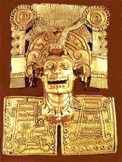
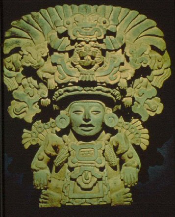
(Left) Gold pendant from tomb dating to the beginning of the 1400s. The pendent
represents Mictllanteuhtli, the 'Lord of Death', recognizable by his
fleshless jaws. (Right) Funerary Urn.
|
(Other
Mexican sites) (Archaeoastronomy)
(Pre-Columbian
Americas Homepage)
|


