|
Location:
Bogazkőy,
Turkey. |
Grid Reference:
40.02� N, 34.62� E
. |
 Hattusa
(Bogazkőy):
(Hittite Capital).
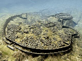 For a
long time it was rumoured that there were four great civilisations
in ancient times: Egypt, Assyria, Mesopotamia and another
which remained unidentified until relatively recently. Each of these
civilisations had its own 'Great King', a title bestowed only upon
the greatest of great. The re-discovery of the city of Hattusa and a
script referring to the 'Great King' of the Hittites has led to
confirmation that they were the fourth, great civilisation of
ancient times. For a
long time it was rumoured that there were four great civilisations
in ancient times: Egypt, Assyria, Mesopotamia and another
which remained unidentified until relatively recently. Each of these
civilisations had its own 'Great King', a title bestowed only upon
the greatest of great. The re-discovery of the city of Hattusa and a
script referring to the 'Great King' of the Hittites has led to
confirmation that they were the fourth, great civilisation of
ancient times.
However, it was the 'Hatti' not the Hittites that
first built Hattusa, existing in their own right as a superpower until the Hittite invasion
in the mid eighteenth century BC. Hattusa was used as the Hittite
capital for another 500 years during which time they conquered vast
swathes of the middle east and Anatolia before they effectively
disappeared from the history books
in an extremely short period of time,
a few short decades towards the latter part of the second millennium
BC, as evidenced in the burnt and empty ruins of their capital Hattusa
and other prominent Hittite cities lying in the arid centre of
Anatolia.
(Map
with Layout of Hattusa)
|
Hattusa: (Hattush, Hattus, Hattusas) |
The Hittite Empire is mentioned over and over in the Bible as one
of the most powerful empires in ancient times and they are even
credited with the original founders of Jerusalem (Ezekiel 16:1). Scholars used to
question the accuracy of the Bible saying that such a big Hittite
Empire was only hearsay since it was nowhere to be found. This was
until the discovery showing the centre of this great civilization, Hattusa � which was then followed by unearthing the treaty of Kadesh
in Egypt establishing the Hittite capital, Hattusa and Heliopolis.
Other important proofs such as remnants, tablets, documents, and
successful excavations soon revealed the truth about the existence
of this great empire
When the first European travelers of the early
19th century found the strange and monumental ruins near Bogazkőy, in
central Turkey, they were puzzled as to the identity of their
mysterious builders, which also appeared to possess a hieroglyphic
writing unlike any other known from antiquity. It was only towards
the end of the 19th century that the ruins of Bogazkőy were finally
identified with those of Hattusa, the ancient capital of the
Hittites
Chronology of Hattusa:
The earliest
traces of settlement on the site are from the sixth millennium
BC. (1)
The Hatti were an
aboriginal people in central
Anatolia who first
appear in the area around the River Kizil Irmak. They spoke a
language called Hattic and did not seem to have a written language
of their own, using
Cuneiform Script
for Trade dealings.
Controlling a significant number of
city states and
small kingdoms, they had established trade with
Sumer by the year
2,700 BC. (2)
In 2,500 BC the Hatti established their capital at the
city of Hattusa
on land that had been occupied much earlier, and referred to the
site as Hattush. They held lands securely in the surrounding
areas, administering laws
and regulating trade in a number of neighbouring states.
Between circa
2,334-2,279 BC the great Sargon of Akkad
invaded the region and, in 2,330 sacked the city of Ur. He then turned his
attention to Hattusa but failed.
Hattic Art flourished around
2,200 BC and, by 2,000 BC, their civilization was at its height with
trading colonies established by the Assyrians at
Hattusa and the city of Kanesh.
A carbonized layer apparent in excavations attests to
the burning and ruin of the city of Hattusa around 1,700
BC. The responsible party appears to have been King
Anitta from
Kussara, who took credit for the act and erected an
inscribed curse for good measure:
At night I took the city by
force; I have sown weeds in its place. Should
any king after me attempt to resettle Hattush,
may the Weathergod of Heaven strike him down.
Hattusas
was not the only city to be destroyed by fire at
this time,
as other cities of Central Anatolia appeared to
have met the same fate: Ala�a Hoyuk, some
25 Km to the North, also perished in a fiery
catastrophe; Hittite palaces at Masat and
Fraktin, as well as the fortified citadel
of Karaogan, near present day Ankara,
were also burnt to the ground in catastrophic
fires. (3)
The mid-eighteenth century BC invasion
of the Hittites, and the destruction of the great city of Hattusa
was followed by
systematic assimilated into the culture of their conquerors. In 1,650 BC
the Hittites, under their warrior-king Hattusili, defeated the last
of the Hatti resistance and rose to complete dominance of the area.
The Hatti region of Anatolia, however, was still known as the 'Land
of the Hatti' until 630 BC, such references found in the writings of both
the Egyptians and the
Assyrians. The artistic renderings of the time depict the common
people with longer noses and markedly different facial features than
those of their leaders, clearly demonstrating the
Hittite lords and
their Hattic vassals. (2)
In
1,279 BC, Ramses II reigned over Egypt, his empire met with that of
the Hittites near the ancient city of Kadesh close to the
borders of present day Syria and the Lebanon. It was here the
'greatest battle the world had ever known' until that time, the
Battle of Kadesh occurred. History recorded
the victory of Ramses II, but the library in the ruins of Hattusa uncovered the peace treaty signed between the two great
kings, which showed that the Hittites had imposed their forces
over the Egyptians pushing the frontier of their empire hundreds
of kilometres south into today's Israel, thus becoming the
greatest empire of the ancient world. Later a permanent peace
treaty was concluded between Ramses II and the Hittite King
Hattusilis III.
The first peace treaty in History (of
which we possess both copies) was signed between the Hittite
King Muwattali II and Ramses II of Egypt after the
battle of Kadesh in Syria.
A few short decades later the
Hittites disappeared for unexplained reasons, until a discovery was made by
modern archaeologists in their excavations at Hattusa. A series
of indecipherable hieroglyphs were discovered in an underground
area, after much research they were finally translated as telling
how the winner of the Battle of Kadesh and the great king
launched themselves into a fratricidal war. Hattusa was
destroyed. The archaeologist discovered the palace and temples
had been burnt down, but not in war, they concluded the city had
been abandoned, the population taking with them everything that
could be carried. The city had been evacuated. Where they went
is a mystery, but in any case the Hittites disappeared forever
from history
during the 'Bronze Age Collapse' c. 1,200 -1,150 BC.
The
City Wall:
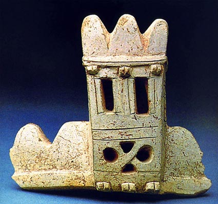
Based on the
discovery (right) in the city of Hattusa itself, a small section of
the great wall was rebuilt using ancient techniques.
The original wall
at over 6km long, would have surrounded the city entirely giving
it an impressive view on approach and raising the status of the city
to its rightful place as capital of the Hittite empire. The enormity
of the task faced by the Hittite master builders becomes obvious
when one considers that the reconstruction represents only one
percent of the ancient 6.6 km long outer fortifications. (The sum of
all elements in the city walls of Hattusa totals more than nine
km's.) Some 2,700 tons of loam, 100 tons of straw, and 1,500 tons of
water were needed for the mud-brick mixture alone. Around 1, 750
tons of earth then had to be moved to provide access ramps for
construction, and a great number of logs brought in for the
construction of the upper rooms in the towers. All the more
remarkable when it is taken into account that mud-brick construction
is limited from June to September. A total of 64,000 bricks (Size:
45 x 45 x 10 cm, weight: 34 kg each) were produced for this section
alone. (5)
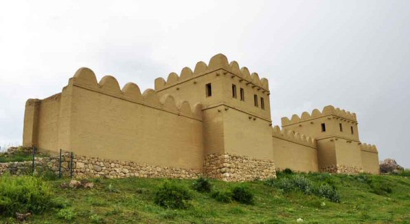
The reconstructed
section of wall at Hattusa.
Yerkapi: 'The
Gate of the Earth'.
One of the most
remarkable monuments of the �Upper city�, is a
large oblong pyramid some 250 by 70 meters wide and 30 meters high
at the southern end of the citadel.
A kind of rampart was built on top of this platform, consisting of a
single line of walls with several towers and two gateways decorated
by sphinxes.

(Photo Credits: A. D. Riddle).
This
huge enigmatic structure is usually called a �fortress� or a �rampart�
but it is at very least, a pyramid shaped structure (without
defensive features). A large
stairways leads up to the summit and a long thin tunnel pierces
it from side to side over a length of 69
meters leading into the middle
of the complex. The two entrances, a small tunnel below and the
'Sphinx gateway' at the top are more suggestive of a different means
of access into the city, with one functional direct route below, and
the other perhaps more for 'public' access, adorned with symbolism
and ceremony.
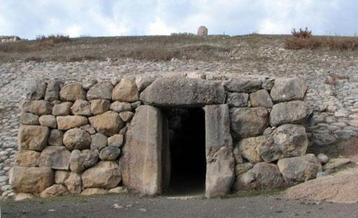
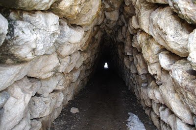
The entrance to
the citadel (left), and an image of the tunnel leading through to
the complex (right).
The Gateway of Sphinx's
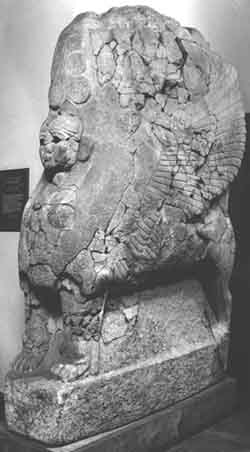 One
of the images most commonly associated with Hittites is the sphinx,
combining a lion's body with an eagle's wings and a human head and
chest. At Hattusa, as at several other prominent Hittite Cities, they
were placed on either side of the main entrance.
At the top of the
Yerkapi platform is the
'Gateway of Sphinxes'.
Unfortunately (or
fortunately), two of the sphinxes were taken
for
restoration to
Germany in 1917. The better preserved sphinx was returned to
Istanbul in 1924, and was placed on display in the
Istanbul Archaeology Museum, whereas the other remained in
Germany, and had been on display at the Pergamon Museum since 1934
(see left).
Previously, Turkey had made numerous requests for its return. In
2011, threats by Turkish Ministry of Culture to impose restrictions
on German archaeologists working in Turkey finally persuaded Germany
to return the sphinx. The Istanbul sphinx was also brought back to
its place of origin and the pair was reunited in Boğazk�y Museum
outside the Hattusa ruin. One
of the images most commonly associated with Hittites is the sphinx,
combining a lion's body with an eagle's wings and a human head and
chest. At Hattusa, as at several other prominent Hittite Cities, they
were placed on either side of the main entrance.
At the top of the
Yerkapi platform is the
'Gateway of Sphinxes'.
Unfortunately (or
fortunately), two of the sphinxes were taken
for
restoration to
Germany in 1917. The better preserved sphinx was returned to
Istanbul in 1924, and was placed on display in the
Istanbul Archaeology Museum, whereas the other remained in
Germany, and had been on display at the Pergamon Museum since 1934
(see left).
Previously, Turkey had made numerous requests for its return. In
2011, threats by Turkish Ministry of Culture to impose restrictions
on German archaeologists working in Turkey finally persuaded Germany
to return the sphinx. The Istanbul sphinx was also brought back to
its place of origin and the pair was reunited in Boğazk�y Museum
outside the Hattusa ruin.
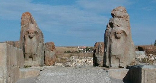
Images: Original
Sphinx from Hattusa (left), Sphinx Gate, at nearby Alaca Huyuk.
(Sphinx
Homepage)
Construction Techniques:
There are several
similarities in the masonry work of the Mycenaean's. The lowest
levels of the foundation blocks of the great walls show a highly
skilled masonry style, often referred to a 'Cyclopean'. The Hittites rebuilt the great city, but
whoever laid the original foundations left behind their familiar
fingerprints in the masonry, still standing today.
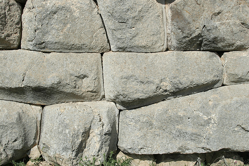
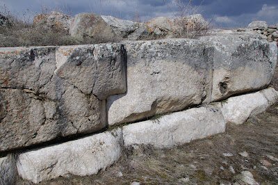
Different examples (and styles) of cyclopean masonry at Hattusa.
The Lion Gate.
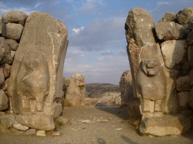
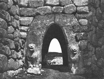
The parabolic
'Lion gate' as it is today (left) and a digital reconstruction
(right).
(Photo Credits (right):
H. Schriever)
The 'Lions Gate' bears a strong similarity to the
construction techniques seem in Mycenaean Greece. In particular,
the 'Lion Gate' at the entrance of
Mycenae itself. Pairs of lions
are common a feature seen at the entrances of several great cities
and complexes
throughout the ancient world. They were considered to symbolize
protection, and are identified with places of importance.
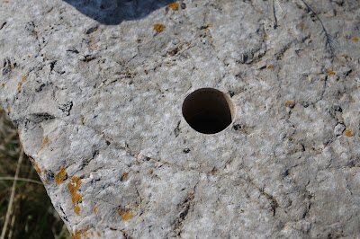 Another enigmatic feature of the temple, which
one also finds almost everywhere amidst the ancient ruins of
Hattusas, is the large number of perfectly circular drill-holes cut
deep into the rock as if by means of some tube drill capable of
drilling perfectly clear holes in a stone as hard as granite. There
is no conclusive explanation as to the real purpose of this holes.
There are hundreds of them found in rocks randomly around the site and they are in some cases so closely
fitted together as to almost entirely cover the surface of a stone
block. It has been suggested these holes served to hold the bronze
pins required to support the wooden frame of buildings, which were
then filled with mud-brick.
(4) Another enigmatic feature of the temple, which
one also finds almost everywhere amidst the ancient ruins of
Hattusas, is the large number of perfectly circular drill-holes cut
deep into the rock as if by means of some tube drill capable of
drilling perfectly clear holes in a stone as hard as granite. There
is no conclusive explanation as to the real purpose of this holes.
There are hundreds of them found in rocks randomly around the site and they are in some cases so closely
fitted together as to almost entirely cover the surface of a stone
block. It has been suggested these holes served to hold the bronze
pins required to support the wooden frame of buildings, which were
then filled with mud-brick.
(4)
(Ancient
Construction Techniques)
Hittite Writing:
Archaeologists found the ancient library of Hattusa with thirty
thousand cuneiform tablets, archived and classified in perfect
order, the greatest ancient library ever discovered. The
language however, was totally unknown to the world of archaeology, even
though cuneiform was of common use in those times by the
Assyrians, Babylonians and Persians in writing their languages.
In the Hattusa archives, native Hurrian
was used frequently for
a wide range of non-official texts such as those on rituals and even
the Epic of Gilgamesh - more so than native Hattian. The Hurrians were migrants to the Upper
Euphrates and Habur basin from the Elburz Mountains east across the
Taurus Mountains from about 2,300 BCE onwards.
For a script, the Hittites used a combination of cuneiform system and
hieroglyphs. The cuneiform Hittites texts were written on clay
tablets that were discovered during excavations at the end of the
19th century CE. Identification of the language had to wait until
1915 when Czech linguist Bedřich Hrozn�, after examining tablets
that had been brought to Vienna from the Istanbul Museum, identified
the language of the Hittite tablets as Indo-European. He published
his findings in a 1917 book titled Die Sprache der Hethiter.
In 1951 a comprehensive Hittite grammar was presented in a book
titled A Comparative Grammar of the Hittite Language by Edgar
H. Sturtevant.
As evidenced by the records discovered, the Hittites had a highly
developed literature consisting of stories, religious texts,
historical records, legal system and legal documents.
Hattusa: The Geographic placement.
One of the most
striking things about Hattusas is that the site chosen for its
construction seems nowhere fit for a large capital, being covered by
rugged terrain amidst steep rock formations: to give you an idea of
how steep and unsuitable the terrain is, suffice to say that the
difference in elevation between the �lower city� and the �upper
city� was well in the range of 300 meters!. Hattusas itself sits on
top of barren and wind-swept plateau at 1,200 meters above sea
level, which enjoys what is possibly the worst weather conditions in
central Anatolia. Even in April the site is mostly covered by snow,
so why build a capital city there?.
We know that before the Hittites, the 'Hatti' also used the location
as their capital city, something which can be recorded back in time
to c. 2,700 BC, and that the Hittites rebuilt their capital city
over the remains of the original Hatti site so perhaps the question
is more: Why did the Hatti choose the site?
At the time of the Hatti
civilisation, the centre of the known world at that time was
Egypt, and most specifically, the capital at Giza (Heliopolis):
Heliopolis (Egypt):
30.01� N, 31.21� E
Hattusa: 40.02� N, 34.2� E
Perhaps it is a coincidence that the Capital of the Hatti empire was
located at distances of exact units of degrees from the geodetic
centre of the world, and perhaps not. We can see that other ancient
capitals such as Persopolis, Knossos, Nimrud, Baalbek and Ur were
also placed at geometrically significant distances from the Egyptian
centre point, and perhaps it is here that one day we will find our
true answer.
(More
about Prehistoric Geodesy)
(A-Z
Index of Sites)
(Homepage)
|


 Another enigmatic feature of the temple, which
one also finds almost everywhere amidst the ancient ruins of
Hattusas, is the large number of perfectly circular drill-holes cut
deep into the rock as if by means of some tube drill capable of
drilling perfectly clear holes in a stone as hard as granite. There
is no conclusive explanation as to the real purpose of this holes.
There are hundreds of them found in rocks randomly around the site and they are in some cases so closely
fitted together as to almost entirely cover the surface of a stone
block. It has been suggested these holes served to hold the bronze
pins required to support the wooden frame of buildings, which were
then filled with mud-brick.