|
Location:
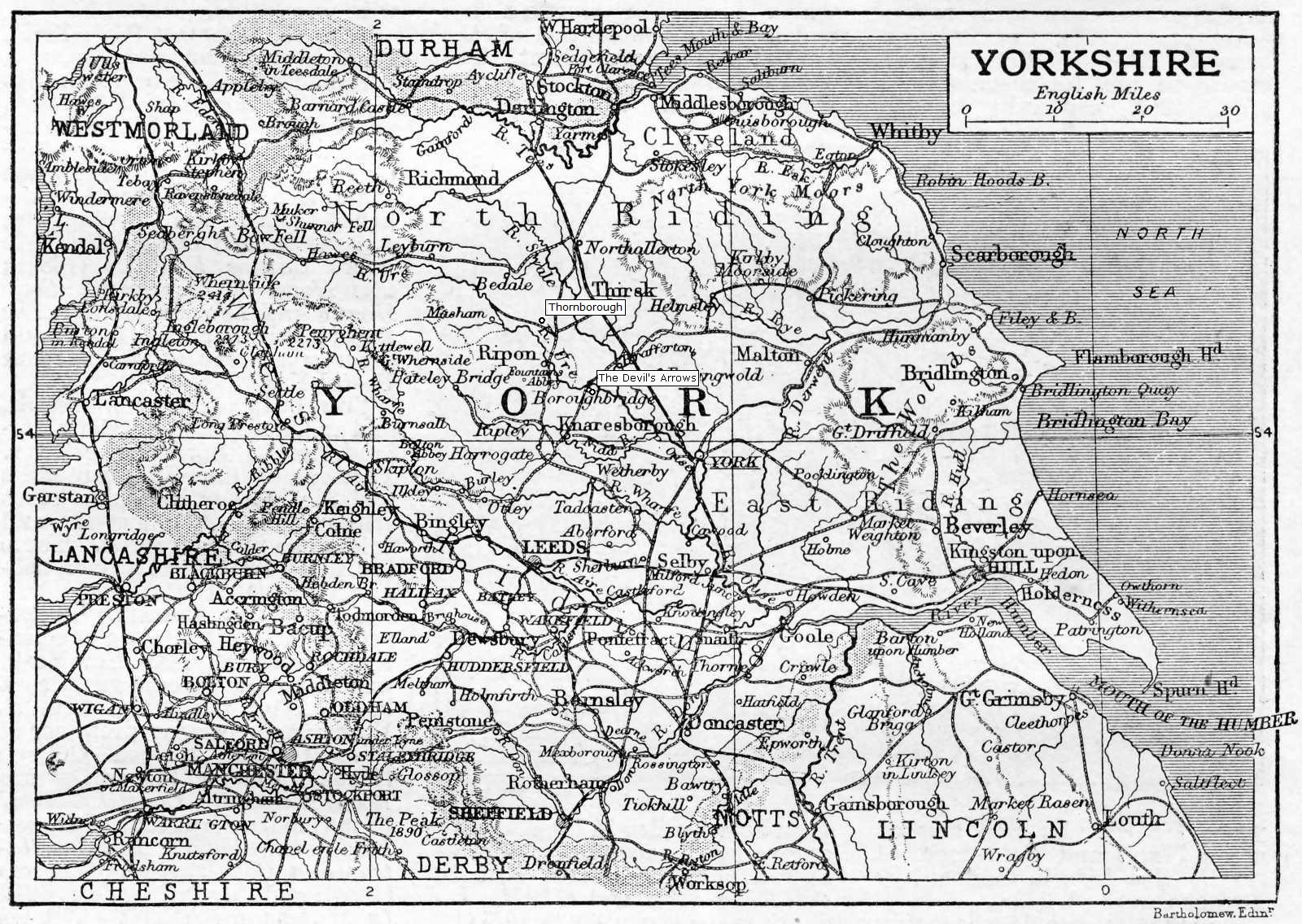
Yorkshire, England.
(O/S SE 319665). |
Grid Reference:
54� 5' 33.5" N,
1� 24' 7.6" W. |
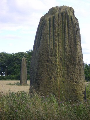
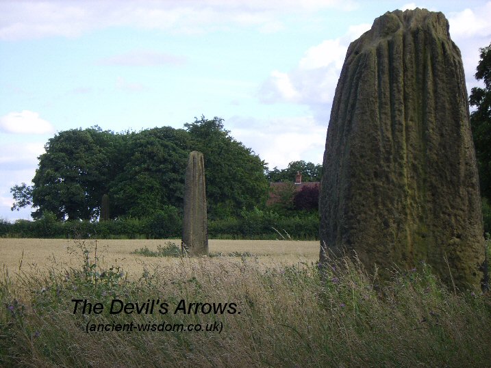
 The Devil's Arrows:
(Menhir Alignment).
The Devil's Arrows:
(Menhir Alignment).
Only three of the original four
(possibly five) stones now remain.
The second largest standing stones
in Britain, and bettered in height only by the
Rudstone
Monument near Scarborough.
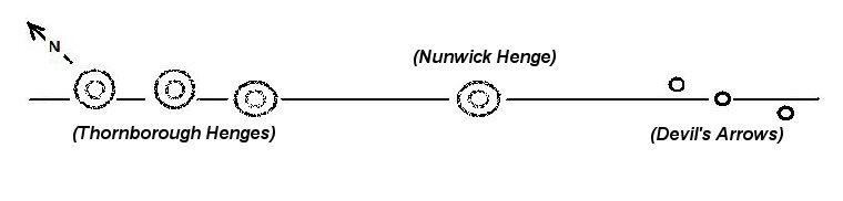
These stones form an important part of the prehistoric
landscape, forming alignments with other sites including several henges
as far away as Thornborough complex (called the 'Stonehenge of the
North'), and one of the most important prehistoric sites in Northern
England.
Alfred
Watkins suggested that these stones were 'mark-stones', of which
he says 'I know of five', and 'close examination shows that...
they must have been cut'
(Click here for Map of site)
('The Devil's Bolts', 'Three Grey Hounds', 'Three Sisters')
Description
- The Devils Arrows sit
next to the A1 at Buroughbridge by the river Ure. Three stones remain,
they are 18ft, 22ft and 22ft 6in tall, the last of these being taller
than anything at Stonehenge. The smallest of the stones is rectangular �
about 8ft 6in by 4ft 6in. The 22ft stone is 5ft by 4ft in girth and the
third and tallest 4ft 6in by 4ft. (1)
Probably originally a five-stone row. The fourth stone was reputedly
broken up in 1582 to build the bridge over the River Tutt, and the fifth
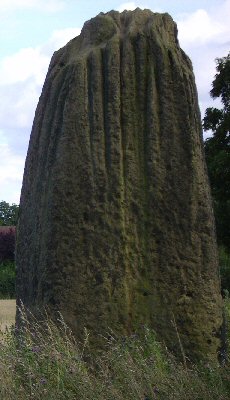
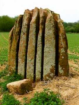
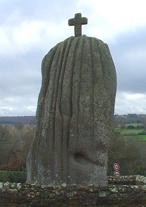
is lost in history. The stones are of grit-stone, having pointed tops,
with a fluted effect also seen in St Uzec,
France, and are buried
over 1.5m into the ground. (An excavation of the smallest stone in
1876 revealed a hole 4ft 6in deep and five years later, an excavation of
the tallest Arrow showed 6ft of it to be buried in the ground)
(1).
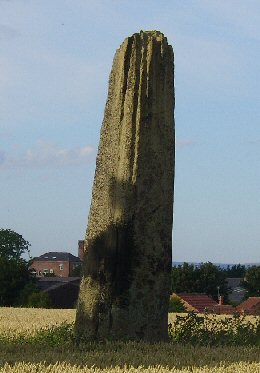
The three stones from North to South, becoming
progressively taller and slimmer.
The stones are composed of
millstone grit and the likely source is Plumpton Rocks two miles south
of Knaresborough where erosion has produced large quantities of
individual slabs. The lightest of the Arrows weighs over 25 tons and
would have had to be pulled over a distance of some nine miles. Recent
experiments (including one televised in 1996 �Secrets of Lost
Empires�) have proved the feasibility of moving and erecting such
stones without the benefit of modern equipment and technology. It is
estimated that the arduous pull from Plumpton to Boroughbridge would
have taken six months.
|
Chronology:
Suggested to have dated from around
2,700 BC (Site Plaque. 2007)
|
More Stones..
'A report of a visit by John Leland in
the 1530s gives a clear and detailed description of four standing stones.
Thirty years later William Camden wrote of seeing �foure huge stones, of
pyramidal forme, but very rudely wrought, set as it were in a straight and
direct line... whereof one was lately pulled downe by some that hoped,
though in vaine, to find treasure�. (1)
Confusingly, the
Yorkshire antiquarian Edmund Bogg (1895) just over a hundred years
ago said:
�Peter
Franck, a fisherman who travelled much about
the world to enjoy his sport, came to
Boroughbridge in 1694 and says he saw seven
of these standing stones, Dr
Stukeley mentions five, and John Leyland, in
his travels, saw �four great stones wrought
by man�s hands,� but no inscription upon
them. Camden, in 1592, saw four, but one of
them at the time was thrown down, �for,�
says he, �the accursed love of gain.� Part
of this one is still to be seen, built into
the Peggy Bridge which crosses the Tut on
the entrance to the town, the top portion
being preserved in the grounds of Aldborough Manor
and this goes far to prove � and I have very
carefully considered the question and
examined the ground � that the original
number of stones was far greater, and
reached from the Yore, in equal distances to
the Tudland of Leyland�s time, or the
Staveley Beck of today. If this argument is
correct, 2000 years ago there would be a
line of at least 12 standing monoliths
guarding the western approach to Isur Brigantium.�
The upper section of the fourth stone is claimed to stand in the
grounds of Aldborough Manor and the lower part is believed to form
part of the bridge which crosses the River Tutt in St. Helena just a
few hundred yards away on the route into the town centre. Large pieces
of the same millstone grit have turned up in the garden of a house
bordering the field in which the enclosure containing the largest
arrow stands. Two large boulders of the same material as the stones
have been found in the garden of a house only a hundred yards or so
from the line of the stones and may possibly be part of the fourth
stone.
|
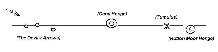
The Alignments.
It is important to highlight
that the three stones do not fall into a straight alignment.
Having noted an alignment relating to the three
Thornborough Circles, one can see that these three henges also share an
offset-alignment, as do the nearby henges on Hutton Moor, and a group of three tumuli there also.
This 'elbow' alignment between three monuments is seen at several other
circles in England, and is often suggested as being related to Orion's
Belt.
(More about Triple-circles)
The Devils Arrows are the centre of the most
important alignment of standing stones, henges and other remains in
Northern England, all running roughly N/S alongside the ancient line of the A1,
Stretching from Hutton Moor to Thornborough and beyond.
In the 1970�s Paul Devereux wrote in
The Ley Hunter�s Companion that "the functions of the monoliths was to
act as a multi-directional sighting or reference instrument." Devereux
also quotes G Bernard Wood on "the Devil�s arrows stand in line "with an
ancient ford across the River Ure."
Deveraux, Pennick and others have noted two
distinct alignments from the Devil's Arrows.
Astronomy -
The most likely astronomical alignment is the alignment
with the southernmost summer moonrise
(1).
The stones were the site of a solstice fair in historical
times according to Stuckley.
(Click here for
more about Geometric Alignments)
|
Mythology.
The story which led to the latter name
is thought to date from the end of the 17th century: Old Nick, irritated by
some slight from Aldborough, threw the stones at the village from his stance
on How Hill (south of Fountains Abbey). His aim, or his strength, being
below par the �arrows� fell short by a good mile. It was also claimed,
and perhaps still is, that walking 12 times around the stones anti-clockwise
will raise the Devil. (1)
|
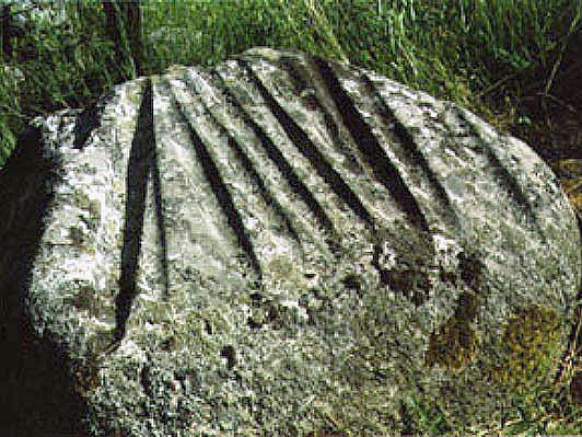
The Grooves: Grooved Stones.
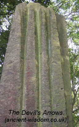
Each of the standing stones has a series of grooves at the top which
are disputably thought to have been carved by man (or the result of weathering). They show no trace of tool working
today � and
the same grooves of varying lengths can be observed at Plumpton rocks
where the stones for the Devil's Arrows are suggested to have originated.
The first recorded excavation at the foot of the stones was in 1709
when a 9ft area around the central stone was opened. This revealed
that, just below the topsoil, cobbles, grit and clay had been packed
around the stone to a depth of 5ft. The base of the stone had been
dressed by pointed tools to produce a smooth bottom which sat squarely on the hard packed
clay beneath.
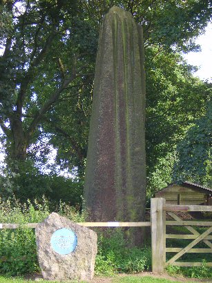
Menhir de St. Uzec, Brittany, France.
Near the end of the 17th century a cross was installed, and the
section below it was carved (on the other side), with the
representations of the instruments associated with the passion of
Christ, including a ladder and a lance. There is/was also a painting
of the crucifixion on the menhir that had to be frequently retouched
because of the high moisture content in Brittany.
Alfred Watkins said that he knew of five
examples of vertically grooved stones. He said of them:
'Most amazing of all, are those like the 'Queen stone'
(Right), near Symonds Yat on the Wye, which have deep grooves running
down them. Several writers (as Mr. O. G. S. Crawford, in "Antiquity")
have stated these to be naturally formed by rain action. But a close
examination shows this to be impossible, and hat they must be
artificially cut. Those of the Queen stone are from 5 to 7 inches deep
and only 2 to 2� inches wide, and
suddenly ceasing near the base of the stone... They are also on all
four sides of the (Queen) stone, whereas if stratification were a
contributing cause, as Mr. Crawford suggests, the grooves could only
be on two sides... The name in old Manor rolls is Quin Stone, and as I
find 'gwyn', which is Welsh for white, is in the Cornish
tongue corrupted to quin, the original name was the white stone,
although its colour is red. Now white stones are mentioned in the
Welsh Triads as of special importance for meetings'.
(2)
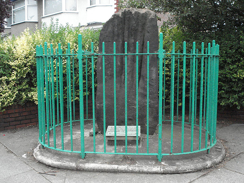
The
Robin Hood's Stone is reputed to be from the Calderstones chambered
tomb (In 1964 the six stones were moved to their present site in the
Harthill Greenhouse in Calderstones Park where they were erected in
random order). It now stands in iron railings on the junction of
Booker Avenue and Archerfield road in Allerton at SJ399863. This stone
has a number of grooves on it similar to The Calderstones, and an old
photograph from Watkin's 'Ley Hunters Manual' shows cup-marks on the
end now buried. Before its present siting in August 1928, the stone
stood in a nearby field known as Stone Hey. The stone was moved when
the site was to be built over. A plaque on the base of the stone
records the bearing from its present position to its former site; 198
feet at a bearing of 7 degrees east of true north.
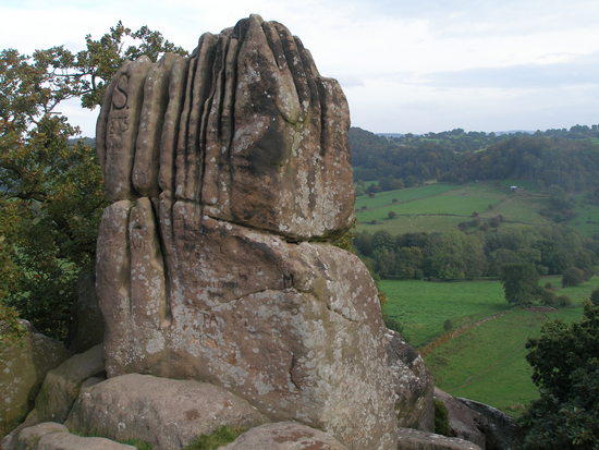
Robin Hoods Stride - Peak District (Right) -
Gotland, Sweden
- There are about 3,600 known grooves on stones scattered throughout
the island of Gotland. 700 are scored directly into the limestone
bedrock, the rest are found on about 800 stones. The length of the
grooves varies from about 0.5 to 1 meter. They are between 5 cm to
10 cm wide and 1 cm to 10 cm in depth. The most important feature of
the grooves appears to be in their alignment. A recent study of 1,256
grooves showed that they are aligned with certain positions of the
celestial bodies, apparently the sun or the moon. Most of them are
oriented east to west. (3)
|
Gallery of Images: The Devil's Arrows.
(Menhirs
Homepage)
(Other Prehistoric English sites)
|