|
Location:
(SO 759355),
Wales. |
Grid Reference:
52˚ 01' 20" N, 02˚ 21' 03". |

 Whiteleaved Oak:
(Perpetual Choir).
This unassuming little hamlet has gained in notoriety recently through the
work of the late John Michell.
Apart from being at the geographic junction of three county borders (Hereford,
Gloucester and Worcester), the proposed centre of John Michell's
'Great Decagon', and therefore, a hub for Britain's ancient 'Perpetual
Choirs' and sitting almost exactly on the 52nd latitude, the importance of
this seemingly invisible village only now remains in its name.
( View
1891-92 O/S Map of Whiteleaved Oak)
(Photo Credits:
Moggz).
This
is the very point where the county boundaries of Hereford, Gloucester and
Worcester meet, and the place name is possibly originated from a sacred variegated or
'white-leaved' oak boundary tree.
The hamlet is also the centre of a large scale
geometric figure called 'The Decagon', which is claimed to connect Megalithic sites across southern
Britain (as identified by John Michell - R.I.P). The three ancient Celtic �perpetual choirs�
that supported spiritual integrity of the country were said by Michell to be at Llantwit Major, Glastonbury Abbey and Stonehenge,
which he determined were three
vertices of a regular decagon of huge proportions. A fourth vertex
exists at Goring-on Thames where a major pagan temple once stood at the
junction of several important track-ways.
The geometry between Whiteleaved Oak, Stonehenge,
Glastonbury and Goring-on-Thames is certainly astonishing, being
accurate to within 3/1000th's of a part. Such accuracy in itself is worth
consideration but when it involves the 'sacred heart' of England
(Glastonbury), its best known ancient monument (Stonehenge)and the
crossing place of two of the most important prehistoric track-ways at Goring
(The Ridgeway.. leading south to Avebury and Stonehenge, and the Icknield
Way), one is forced to take notice of Michell's work.
(More about the 'Great Decagon')
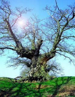
'There is an ancient oak tree
situated in farmland on the lower western slopes of Ragged Stone Hill,
between the hamlets of Hollybush and White Leaved Oak. The gnarled old
oak must have a diameter of around 2 meters, and grows remarkably atop
a large flat rock on the north ridge of a sizeable, deep hollow in the
ground. To the north east of the hollow is an entrance passage that
one could reasonably assume is man made, and two other younger oaks
grow on the south eastern and south western corners to form a
triangle.
There is rumour that the original
tree was in fact not at the location of the current tree at all but
some distance away nearer the hamlet of White Leaved Oak. The story
goes that it was blown down in a storm many years ago and residents
planted a new oak in its place. It was said that this �original� tree
did in fact have white leaves, thus lending its name to the
neighbouring hamlet. A local resident living in White Leaved Oak
claims that the story of the leaves is untrue, and that the name in
fact originates from a disease of oak trees which causes their leaves
to turn white.
There is a well used hearth where fires are burnt
late into the night (until very recently there were two hearths but
these have wisely been consolidated to create one larger fireplace) and
at the solstices gifts are left hanging from the sacred oaks sturdy
branches. At the summer solstice the oak was left strewn with blossoms
and flowers and decked with brightly coloured ribbons, feathers,
pentagrams and other trinkets and crafts. Until recently there was even
a makeshift �visitors book� left in a sheltered hollow in the trees�
trunk that was rapidly filled with signatures, poems and blessings, but
this has since become damaged and been removed. The trunk and many
branches of the tree have become hollowed with age, and it is now
possible to climb down inside the trunk of the oak and stand on the rock
upon which it grows. The inside of the tree is also lined with trinkets,
gemstones and jewels left as gifts'.
(1)
Whiteleaved Oak and Geodesy.
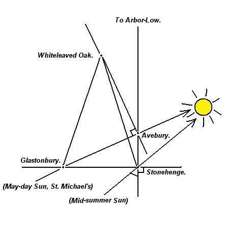
Having seen that Whiteleaved Oak shares a common geometric
connection to both Stonehenge and Glastonbury, it is perhaps not so
surprising to find that all three sites are also geometrically connected
to Avebury/Silbury too as the following diagram illustrates:

It is perhaps no coincidence that Whiteleaved Oak
sits so close to the 52nd latitude (52˚
01' 20" N).
The pivotal
geodetic role of the village can only be fully realised when one
realises that several of the most important prehistoric sites also
appear to have been located according to geometric principles which
appear to show a working knowledge of longitude and latitude (using a
360�
division of the globe).
(More about English
Geodesy)
(More about the 'Great
Decagon')
(Other
Welsh Sites)
|