|
Location: Waterval Boven,
Mpumalanga,
South Africa. |
Grid Reference:
25� 37' 54.12" S 30� 45� 36.09" E. |
 'Adam's Calendar':
('Stone setting').
'Adam's Calendar':
('Stone setting').
Controversially
suggested to be the oldest man-made site on earth by
Michael Tellinger and Johan Heine.
There are two distinct sets of remains in
question: The 'Bantu Kraals'... and
'Adams Calendar'.
Tellinger claims that
both the ruins and 'calendar' stones were inspired by the
Sumerian Anunaki, and that they date from 260,000 years ago. He has
also suggested that these are the remains of Enki's lost mythological Sumerian city of Abzu (Hell), where he
believes the first humans were used as slaves to mine for gold.
He also states that Great Zimbabwe was Enki's 'Headquarters',
simultaneously dating it to c. 260,000 years old.
(3)
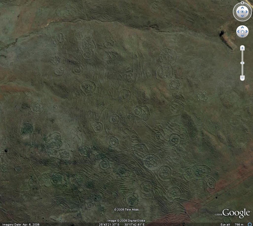
When historians first stumbled upon these
structures they assumed that they were cattle kraal left
behind by the Bantu people as they moved south and settled the
land from around the 13th century. This idea today seems
unlikely as a definitive answer, as there are several thousand
similar ruins spread over tens of thousands of miles. The design
of the structures is unlike any other Bantu cattle-kraal
designs, which are usually made of thorny shrubs, with a single
entrance/exit for the cattle. The complexity, design and high
number, offer the possibility that these are the remains of a
lost 'cultural activity' hitherto unaccounted for in the region.
Tellinger said of
the ruins: 'Our research has shown that the ancient ruins of
South Africa and Zimbabwe go back to around 260,000 years the very
first appearance of humans on Earth'.
(3)
This is an unsubstantiated statement,
with no evidence to support it. Without more accurate evidence
however, we are left with the suggestion that the remains are from
the 13th century. However, as we can see from the photo above, there
is little, if any similarity to the Bantu kraal (below). The first estimates of the number of
stone ruins was made in 1891 by Theodore
Bent who had a real fascination with the
stone ruins. He was also the first person to
document his excavations of Great
Zimbabwe at the time and estimated that
there were about 4,000 stone ruins in
this part of the world. This estimate
has now been raised to around 20,000 ruins.
Typical
Bantu Village Showing type of housing,
layout and design.
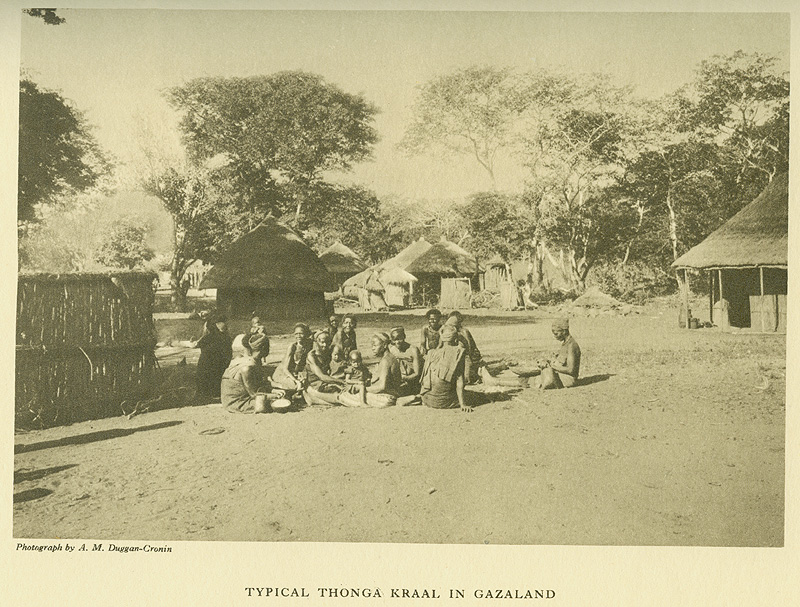
Source: A. M.
Duggan-Cronin, The Bantu Tribes of South
Africa: Reproductions of Photographic
Studies (Cambridge, U.K.: Deighton,
Bell, 1935), vol. 4, Henri P. Junod, The
Vathonga (The Thonga-Shangaan People),
plate 24.
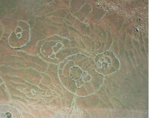
As we can
see, many of the stone ruins appear to have
been repeatedly built over.
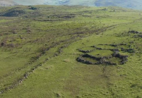
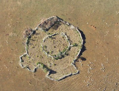
Left: 'Kraal' with
adjacent 'roadway', Right: Unusual 'Kraal'
without entrance/exit.
Archaeology of the Region:
Apart from
such glimpses into history, as well as
well-made iron and stone artefacts that were
collected, little is known about the
archaeology of the mountain-lands. From July
1952 to 1955 some 1915 artefacts were
collected from 20 sites around Barberton,
including the mountain lands. These are at
present housed in the Barberton museum. The
artefacts were collected from open donga
sites where material of all ages was mixed
on the surface. Earlier Stone Age
(approximately 1 million to 200 000 years
ago) implements were exposed at various
depths in the deep dongas, Middle Stone Age
(125 000 to 75 000 years) material occurred
in the ferricrete overlying the subsoil, and
Later Stone Age (between 30 000 and 40 000
years ago until about 2 000 years ago)
artefacts were exposed by surface erosion.
Even today many Late Stone Age artefacts are
encountered on walks in the highlands.
(4)
However, the
remains of ancient cultures that must once
have thrived in the area are numerous.
Terraces and rock packed structures can be
found in the mountain-lands and research by
Dr. Cyril Hromnik has it that the Dravidian
merchant caste of southern India mined gold
here 2000 years ago, resulting in these
stone structures, celestial calendars as
well as temples. Since 1984 interest in the
early history of the Barberton goldfields
has been revived by Dr. Hromnik�s
controversial research and his discovery in
this area, of what he claims to be ancient
megalithic Dravidian religious structures.
Hromnik is of the opinion that an area
known, as Komati-land was the trading zone
of the Dravidians and that their presence in
fact predates the appearance of the first
Bantu in this part of Africa by centuries.
The oral tradition of the local Swazi (Siswati),
who settled in this area only relatively
recently, in the first half of the 19th
century, has little to say about these early
gold miners. However the Swazi people are
almost unanimous in attributing the stone enclosures, stonewalled roads and other stone structures
that occur in the vicinity of the gold workings to the beSutfu. By
calling these ancient stone-builders beSutfu the Swazi traditions do
not refer, as is popularly believed, to the modern Bantu-speaking
BaSotho (meaning �Black People�). �Sutfu is not just a Nguni variant
of the name Sotho; the reference is, rather, to people of the uSutu
River.
(4)
Gold Mining:
It has been
noted that the area is extremely rich in
gold. Several mining shafts have been
reported in the area. Not only did the rich gold reefs
attract attention in the 1880�s, but the
early evidence of historic civilizations
mining for minerals were described in
writings by the early Europeans.
Firstly, the prospectors found that
others before them exploited gold by
primitive methods. As D. Wilson (1901)
Mining Commissioner and Landdrost of
Kaapsche Hoop (then called Duiwels
Kantoor), reported:
�Another curious and puzzling
find, affording evidence of a very high
degree of civilization on the part of
the ancient explorers of De Kaap, took
place within a few yards of my office at
the Kantoor. Running into the side of a
steep hill, was the remains of a tunnel,
which was opened up in the course of
prospecting work, when the diggers
unearthed two earthenware pipes about
three feet long and six inches in
diameter. They had most of the signs one
looks for in ancient pottery and were
obviously of very great age�.
Who the ancient miners were, still
remains an unresolved and tantalizing
secret, and depending on one�s
viewpoint, great efforts are made to
attribute it to San people, Dravidian
merchants form the Indian sub-continent,
Arabs, Phoenicians and even Egyptians.
Evidence of dwellings estimated to be
some 500 years old can be interpreted as
part of a culture that traded gold with
eastern (Arabic and Indian) communities
in the past. At least one such complete
Iron Age �village� is found on
mountain-lands as well as various other
sites still to be verified.
(4)
Great Zimbabwe:
Great Zimbabwe is a
ruined city that was once the capital of the
Kingdom of Zimbabwe, which existed from around 1100 to 1450. The word
"Great" distinguishes the site from the many hundreds of small
ruins, known as Zimbabwe's, spread across the Zimbabwe highveld. The
Capital of the Zimbabwe kingdom lies approximately 500 miles north
of the site known as Adam's Calendar (below). Archaeological
evidence suggests that Great Zimbabwe became a centre for trading,
with artefacts suggesting that the city formed part of a trade
network extending as far as China. This international trade was
mainly in gold and ivory; some estimates indicate that more than 20
million ounces of gold were extracted from the ground.
(5)
It is in this very same region that one finds 'scattered
throughout the strata and rocks ... deposits of reef and alluvial
gold, and also iron, talc, asbestos and nickel'
(4),
offering a reasonable explanation for such a high concentration of
ancient structures.
The gold-rich soil, the presence of
ancient mines and an ancient local
historical focus on mineral trade (i.e. the
Zimbabwe kingdom) hint at an association
between these extensive ruins and the
natural resources of the region.
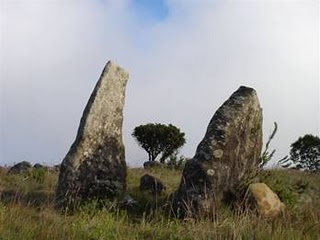
The stone setting
now called 'Adam's Calendar' was first brought to the publics
attention in 2003 by pilot Johan Heine. The stones are arranged on
the precipice of the Transvaal Escarpment overlooking the Waterval
Boven Valley. The stones are all dolomite, weighing up to 5-tons
each, and are claimed to have been transported from a distance to
the site as the Escarpment itself is composed of Black Reef
Quartzite, rich in gold. (9)
It is claimed that the stones would have originally stood in a
circle, and that the remaining stones denote the cardinal points
(off by 3�)
and the rising/setting points of the solstice sun. In the centre of
the 'circle' are two upright stones which are said to have been
carved.
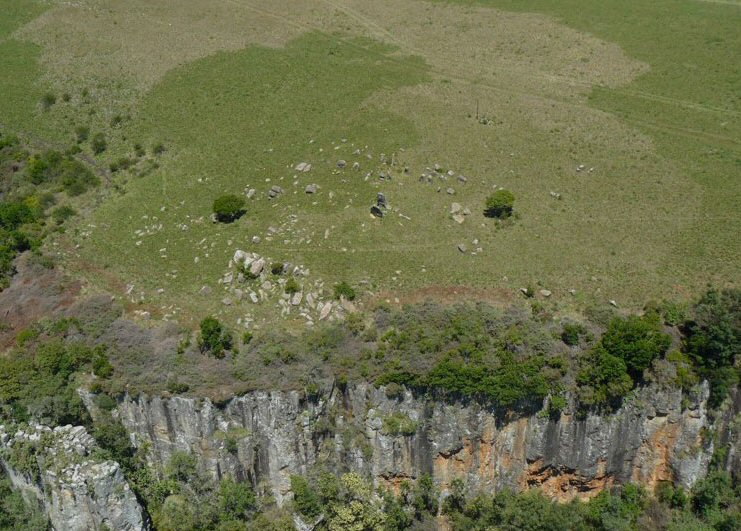
'Adam's Calendar'
as seen from above.
Computer
generated view of the site.
It is claimed that
the monolithic stones were transported from two
miles away. This is apparently based on a geology report that
indicates the rocks were moved here and worked with human hands.
(8) The following two references to
the region both make reference to Dolomite being common.
'Aloe alooides (Bolus) .... Large
single-stemmed aloe, 1-3 m: on rocky dolomite slopes in
grassland and bushy thickets... Distribution: endemic to
Mpumalanga, occurring sporadically on dolomite between
Sudwala Caves and Blyde River Canyon N.R'.
(6)
'Bird watchers should
not miss out on an opportunity to see Chrissiesmeer, which
is the largest natural freshwater lake in South Africa, and
famous for flamingos. The Sudwala Caves deep in the dolomite
rocks of the surrounding mountains, are worth visiting'
(7)
|
Dating The Site:
These widely varying estimates all come from the same
source: Michael Tellinger.
'The first rough
calculation was from at least 25,000 years ago.
But new and more precise measurements kept
increasing the age'...
The next calculation was
presented by a 'master archaeoastronomer'
(Bill Hollenbach?(8)) who
unsurprisingly, wishes to remain anonymous for
'fear of
ridicule by the academic fraternity'. The
calculation was apparently based on the rise of
Orion and suggested an age of at least
75,000 years.
(2)
A
further calculation in June 2009, suggested an age
of at least 160,000 years, based on the rise of
Orion 'flat on the horizon' but also on the 'erosion
of dolerite stones' found at the site. Some pieces
of the marker stones had been broken off and sat on
the ground, exposed to natural erosion. When the
pieces were put back together about 3 cm of stone
had already been worn away. These calculation helped
assess the age of the site by calculating the
erosion rate of the dolerite.
(2)
'Our research has shown that the ancient ruins of
South Africa and Zimbabwe go back to around 260,000
years the very first appearance of humans on Earth'.
(3)
At present (2011), the site has not undergone any
official dating procedures.
|
It is regularly
claimed that
'Adam's Calendar' is located on the same line of longitude as Giza
and Great Zimbabwe. Using Google Earth's lat/long grid Giza is approximately 45km west of the nearest Adam's Calendar
longitude line.
While the following
images certainly suggest a human provenance for the stones, there is
no evidence to support Tellinger's claims that they are '75,000
years or older'.
Gallery of Images:
|
|
 |
|
The Two Central Uprights. |
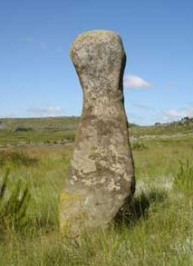
The 'Anthropomorphic' Menhir.
|
(Axum, Ethiopia)
(The Giza
Complex)
(The Sphinx)
(Egypt
Homepage)
(Egyptian Astronomy)
(Index of
Ancient Sites)
(Homepage)
|